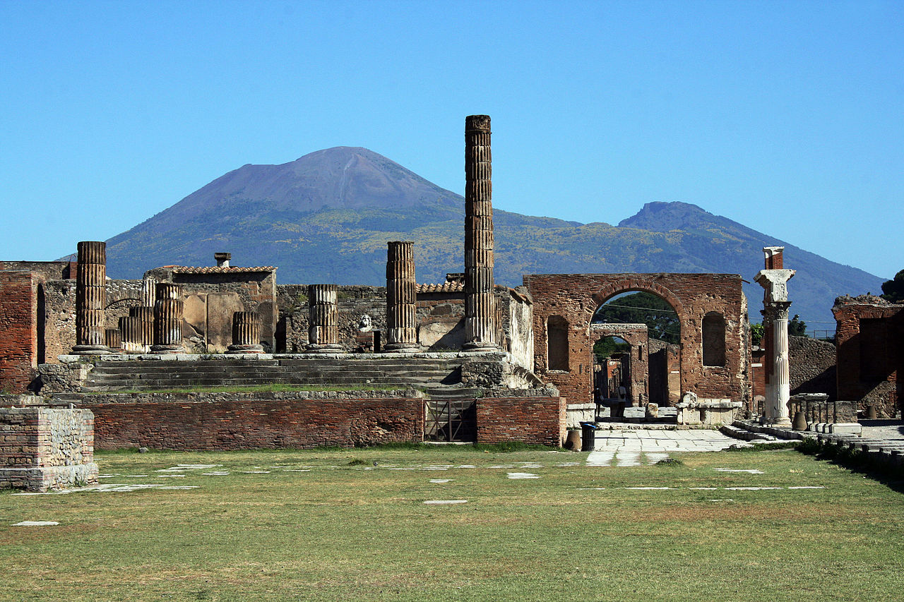


Photo: Glen Scarborough from The Central Coast, Australia, CC BY 2.0 · Wikimedia Commons
Archaeological site, 6th century BC
Pompeii
Ancient Roman city near modern Naples, Italy
- Within the UNESCO World Heritage Site “Archaeological Areas of Pompei, Herculaneum and Torre Annunziata”
- Free on the first Sunday
At a glance
- Type
- Archaeological site
- Period
- Antiquity, 6th century BC
- Area
- 980,500 m²
- Coordinates
- 40°45′02″ N, 14°29′23″ E
History and description
Pompeii was a city in what is now the municipality of Pompei, near Naples, in the Campania region of Italy. Along with Herculaneum, Stabiae, and many surrounding villas, it was buried under 4 to 6 m (13 to 20 ft) of volcanic ash and pumice in the eruption of Mount Vesuvius in 79 AD.
Largely preserved under the ash, Pompeii offers a snapshot of Roman life, frozen at the moment it was buried, as well as insight into ancient urban planning. It was a wealthy town of 10,000 to 20,000 residents at the time it was destroyed. It hosted many fine public buildings and luxurious private houses with lavish decorations, furnishings and artworks, which were the main attractions for early excavators; subsequent excavations have found hundreds of private homes and businesses reflecting various architectural styles and social classes, as well as numerous public buildings. Organic remains, including wooden objects and human bodies, were interred in the ash; their decay allowed archaeologists to create moulds of figures in their final moments of life.
History
Although best known for its Roman remains visible today, dating from AD 79, it was built upon a substantial city dating from much earlier times. Expansion of the city from an early nucleus (the old town) accelerated after 450 BC under the Greeks following the Battle of Cumae.
The first stable settlements on the site date to the 8th century BC when the Oscans, a population of central Italy, founded five villages in the area.
With the arrival of the Greeks in Campania from around 740 BC, Pompeii entered the orbit of the Hellenic people. The most important building of this period is the Doric Temple, built away from the centre in what would later become the Triangular Forum. At the same time the cult of Apollo was introduced. Greek and Phoenician sailors used the location as a safe port.
In the early 6th century BC, the settlement merged into a single community centred on the important crossroad between Cumae, Nola, and Stabiae and was surrounded by a tufa city wall (the pappamonte wall). The first wall (which was also used as a base for the later wall) unusually enclosed a much greater area than the early town together with much agricultural land. That such an impressive wall was built at this time indicates that the settlement was already important and wealthy. The city began to flourish and maritime trade started with the construction of a small port near the mouth of the river. The earliest settlement was focused in regions VII and VIII of the town (the old town) as identified from stratigraphy below the Samnite and Roman buildings, as well as from the different and irregular street plan. …
Roman city development
Owing to its wealth and its Greek, Etruscan and Roman history, Pompeii is of great interest for the study of Ancient Roman architecture in terms of building methods and urban planning. However, it was a relatively small provincial city and, except for the Amphitheatre, it did not have large monuments on the scale of other Roman cities. It also missed the large building schemes of the early Empire and kept much of its urban architecture dating from as early as the 4th century BC.
The evolution of Pompeii's private and public buildings is often unclear because of the lack of excavations beneath the levels of 79. It is, however, clear that by the time of the conquest by Sulla in 89 BC, the development of the street layout was largely complete, and most of the insulae were built.
Under the Romans, Pompeii underwent a process of urban development which accelerated in the Augustan period from about 30 BC. New public buildings included the Amphitheatre with palaestra or gymnasium with a central natatorium (cella natatoria) or swimming pool, two theatres, the Eumachia Building and at least four public baths. The amphitheatre has been cited by scholars as a model of sophisticated design, particularly in the area of crowd control.
Other service buildings were the Macellum ("meat market"); the Pistrinum (baker); the thermopolia (inns or snack-bars that served hot and cold dishes and drinks), and cauponae ("pubs" or "dives" with a seedy reputation as hangouts for thieves and prostitutes). At least one building, the Lupanar, was dedicated to prostitution. A large hotel or hospitium (of 1,000 m2) was found nearby at Murecine/Moregine, when the Naples-Salerno motorway was being built, and the Murecine Silver Treasure and the Tablets (providing a unique record of business transactions), as well as the Moregine bracelet, were discovered there.
An aqueduct provided water to the public baths, to more than 25 street fountains, and to many private houses and businesses. The aqueduct was a branch of the great Serino Aqueduct built to serve the other large towns in the Bay of Naples region and the important naval base at Misenum. The castellum aquae is well preserved and includes many details of the distribution network and its controls. …
Text from Wikipedia, the free encyclopedia, under CC BY-SA 4.0. Full article: «Pompeii».
Timeline
- 6th century BCBuilt
- 88 BCSiege
- 59 ADRiot
- 62 AD62 Pompeii earthquake
- 79 ADEruption of Mount Vesuvius in 79Destruction
Events and people from Wikidata (CC0).
Photos
Getting there
Pompei Scavi - Villa dei MisteriTrain, nearest
800 m as the crow flies
Pompeii
Porto di Castellammare di Stabia6.5 km
Aeroporto di Napoli Capodichino22.5 km
Distances are as the crow flies, not walking or driving.
Loading map…
Nearby
See on the mapMore archaeological sites in Campania

- UNESCO
- Free 1st Sunday

- UNESCO

- UNESCO

- UNESCO
- Free 1st Sunday

Frequently asked questions
Where is Pompeii?
Pompeii is in Pompei, in the province of Napoli (Campania), Italy. GPS coordinates: 40.75056, 14.48972.
Can I visit Pompeii for free?
Yes: entry is free on the first Sunday of every month, under the Italian “Domenica al museo” scheme.
How old is Pompeii?
Wikidata dates it to the 6th century BC.
What else is there to see near Pompeii?
Nearby you’ll find: House of the Lararium of Achilles (0 m away), House of the Ceii (100 m away), Archaeological excavations of Pompeii (100 m away).
Sources and licences
Text. Wikipedia, the free encyclopedia (CC BY-SA 4.0).
Data. Wikidata (CC0); opening hours and contacts OpenStreetMap (ODbL).
Photos. Wikimedia Commons, author and licence on every image.
Credits for the 2 photos
- Pompeii (4873744179) — Glen Scarborough from The Central Coast, Australia, CC BY 2.0
- Pompei dal campanile — Giov.c, CC BY-SA 4.0
Updated 28 October 2026. All sources and licences