





Photo: Carsten Steger, CC BY-SA 4.0 · Wikimedia Commons
Archaeological site, 599 BC
Archaeological site of Paestum
Ancient Greek city in present-day village Paestum, Italy
Capaccio Paestum (SA), Campania
At a glance
- Type
- Archaeological site
- Period
- Antiquity, 599 BC
- Elevation
- 18 m above sea level
- Protection
- Part of UNESCO World Heritage Site
- UNESCO World Heritage
- Cilento and Vallo di Diano National Park with the Archeological Sites of Paestum and Velia, and the Certosa di Padula
- Coordinates
- 40°25′21″ N, 15°00′20″ E
- Address
- Via Magna Graecia, 917/919
History and description
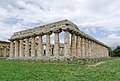
Paestum was a major ancient Greek city on the coast of the Tyrrhenian Sea, in Magna Graecia. The ruins of Paestum are famous for their three ancient Greek temples in the Doric order dating from about 550 to 450 BCE that are in an excellent state of preservation. The city walls and amphitheatre are largely intact, and the bottom of the walls of many other structures remain, as well as paved roads. The site is open to the public, and there is a modern national museum within it, which also contains the finds from the associated Greek site of Foce del Sele.
Paestum was established around 600 BCE by settlers from Sybaris, a Greek colony in southern Italy, under the name of Poseidonia (Ancient Greek: Ποσειδωνία). The city thrived as a Greek settlement for about two centuries, witnessing the development of democracy. In 400 BCE, the Lucanians seized the city. Romans took over in 273 BCE, renaming it Paestum and establishing a Latin colony. Later, its decline ensued from shifts in trade routes and the onset of flooding and marsh formation.
Ancient ruins and features
Much of the most celebrated features of the site today are the three large temples in the Archaic version of the Greek Doric order, dating from about 550 to 450 BCE. All are typical of the period, with massive colonnades having a very pronounced entasis (widening as they go down), and very wide capitals resembling upturned mushrooms. Above the columns, only the second Temple of Hera retains most of its entablature, the other two having only the architrave in place.
These were dedicated to Hera and Athena (Juno and Minerva to the Romans), although previously they often have been identified otherwise, following eighteenth-century arguments. The two temples of Hera are right next to each other, while the Temple of Athena is on the other side of the town center. There were other temples, both Greek and Roman, which are far less well preserved.
Paestum is far from any sources of good marble. Unsurprisingly, the three main temples had few stone reliefs, perhaps using painting instead. Painted terracotta was used for some detailed parts of the structure. The large pieces of terracotta that have survived are in the museum.
The whole ancient city of Paestum covered an area of approximately 120 hectares. Only the 25 hectares that contain the three main temples and the other main buildings have been excavated. The other 95 hectares remain on private land and have not been studied.
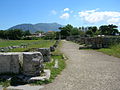
The ancient city was surrounded by defensive walls, which are largely intact. The walls are approximately 4.75 km (3 mi) long in its polygonal perimeter, typically 7 m (23 ft) high, and 5–7 m (16–23 ft) thick. Corresponding with the cardinal points, there were four main openings in the wall: Porta Sirena (east to the hills); Porta Giustizia (south, now to the modern village Paestum); Porta Marina (west to the sea); and Porta Aurea (north), which was later destroyed. Positioned along the wall were 24 square or round towers. There may have been as many as 28, but some of them (and Porta Aurea) were destroyed during the construction of a highway during the 18th century that effectively cut the ancient site in two. …
History
According to Strabo, the city was founded as Poseidonia (named after the Greek deity of the sea) by Greek Achaeans from Sybaris. The colonists had built fortifications close to the sea, but then decided to found the city farther inland at a higher elevation. Solinus wrote that it was established by Dorians. The fortifications might have been built to the south of Poseidonia on the promontory where Agropoli is now. According to the historical tradition the sanctuary to Poseidon was located there, after which the city would have been named. The date of Poseidonia's founding is not given by ancient sources, but the archaeological evidence gives a date of approximately 600 BCE.
Alternatively in fact, the Sybarites may have been Troezenians. Aristotle wrote that a group of Troezenians was expelled from Sybaris by the Achaeans after their joint founding of that city. Gaius Julius Solinus calls Paestum a Dorian colony and Strabo mentions that Troezen once was called Poseidonia. As a consequence it has been argued that Paestum was founded by the Troezenians referred to by Aristotle. Another hypothesis is that the Sybarites were aided by Dorians in their founding of Poseidonia.
Archaeological evidence from Paestum's first centuries indicates the building of roads, temples, and other features of a growing city. Coinage, architecture, and molded votive figurines all attest to close relations maintained with Metaponto in the sixth and fifth centuries.
It is presumed that Poseidonia harbored refugees from its mother city, Sybaris, when that city was conquered by Croton in 510 BCE. In the early fifth century, Poseidonia's coins adopted the Achaean weight standard and the bull seen on Sybarite coins. A. J. Graham thinks it was plausible that the number of refugees was large enough for some kind of synoecism to have occurred between the Poseidonians and the Sybarites, possibly in the form of a sympolity.
Poseidonia might have had a major share in a new foundation of Sybaris, which lasted from 452/1 BCE until 446/5 BCE. This is suggested by the great resemblance of the coins of Sybaris to those of Poseidonia during this period. Possibly a treaty of friendship between Sybaris, its allies, and the Serdaioi (an unknown people) dates to this new foundation, because Poseidonia was the guarantor of this treaty. …
Rediscovery
Despite stray mentions such as that in the history of Pietro Summonte in 1524, who correctly identified the three Doric temples as such, its ruins only came to wide notice again in the eighteenth century, following the rediscovery of the Roman cities of Pompeii and Herculaneum, and during the construction of a new coastal road south from Naples. The modern settlement had begun to revive by at least the sixteenth century, to the side of the ancient ruins. After a complicated start, the rediscovery of the three relatively easily accessible, and early, Greek temples created huge interest throughout Europe.
Giovanni Battista Piranesi visited to make a book of highly atmospheric but also accurate etchings, published in 1778; these and other prints were widely circulated. The complete and relatively simple form of the temples became influential in early Greek Revival architecture.
In 1740 a proposal was made, but not executed, to remove columns for the new Palace of Capodimonte in Naples. Initially, eighteenth-century savants doubted that the structures had been temples, and it was suggested variously, that they included a gymnasium, a public basilica or hall, or a "portico". There also was controversy and misunderstanding of their cultural background. Alessio Simmaco Mazzocchi, a clergyman and antiquarian, "the founder of the modern study of Magna Graecia" (the ancient Greeks in Italy), thought they were Etruscan, in line with his theories that Greek colonists merely had joined existing cultures in Italy, founded by peoples from farther east. He derived the etymology of "Poseidonia" from an invented Phoenician sea deity.
The first modern published account of the ruins was Les Ruines de Paestum in 1764, by G. P. M. Dumont, who had been taken to the site in 1750, along with the architect Jacques-Germain Soufflot, by Count Gazzola, an engineer for the government in Naples. Gazzola had drawn or commissioned measured drawings, to which Dumont added his own, as well as, more artistic plates. There was an expanded edition in 1769, the same year when a still more extensive account was published by the Englishman Thomas Major. By 1774 there were nine different illustrated publications on the site. …
Text from Wikipedia, the free encyclopedia, under CC BY-SA 4.0. Full article: «Archaeological site of Paestum».
Timeline
- 599 BCBuilt
Events and people from Wikidata (CC0).
Photos
Getting there
PaestumTrain, nearest
800 m as the crow flies
Archaeological site of PaestumVia Magna Graecia, 917/919
Port7.9 km
Aeroporto di Salerno - Costa d'Amalfi23.2 km
Distances are as the crow flies, not walking or driving.
Loading map…
Nearby
See on the mapMore archaeological sites in Campania

- UNESCO
- Free 1st Sunday

- UNESCO

- UNESCO

- Free 1st Sunday

Frequently asked questions
Where is Archaeological site of Paestum?
Archaeological site of Paestum is in Capaccio Paestum, in the province of Salerno (Campania), Italy. Address: Via Magna Graecia, 917/919. GPS coordinates: 40.42263, 15.00557.
Can I visit Archaeological site of Paestum for free?
Yes: entry is free on the first Sunday of every month, under the Italian “Domenica al museo” scheme.
How old is Archaeological site of Paestum?
Wikidata dates it to 599 BC.
What else is there to see near Archaeological site of Paestum?
Nearby you’ll find: Amphitheatre of Paestum (100 m away), Forum (100 m away), National Archaeological Museum of Paestum (100 m away).
Sources and licences
Text. Wikipedia, the free encyclopedia (CC BY-SA 4.0).
Data. Wikidata (CC0); opening hours and contacts OpenStreetMap (ODbL).
Photos. Wikimedia Commons, author and licence on every image.
Credits for the 9 photos
- Aerial image of Paestum (view from the south) — Carsten Steger, CC BY-SA 4.0
- ISS026-E-29574 - View of Italy - Torre Licinella (Capaccio Paestum) - Santa Venere - Paestum - Baia di Agropli (cropped) — Earth Science and Remote Sensing Unit, Lyndon B. Johnson Space Center, Public domain
- Italie Paestum - panoramio — rene boulay, CC BY-SA 3.0
- Landscape near Paestum — Richard Mortel, CC BY 2.0
- Paestum - Paestum - Tagzania - 1766933571827 — Xuban (Tagzania user ID: 3827), CC BY-SA 4.0
- Paestum Juli 2023 1 — Kasa Fue, CC BY-SA 4.0
- Paestum Juli 2023 — Kasa Fue, CC BY-SA 4.0
- Paestum via Sacra — Golfodisalerno, CC BY-SA 4.0
- Paestum-140-Saeule-Oleander-1986-gje — Gerd Eichmann, CC BY-SA 4.0
Updated 28 October 2026. All sources and licences