




Photo: Freddyballo, CC BY-SA 3.0 · Wikimedia Commons
At a glance
- Type
- Historic village
- Elevation
- 15 m above sea level
- Area
- 77,200,000 m²
- Coordinates
- 40°08′52″ N, 18°29′09″ E
History and description
Otranto is a coastal town, port and comune in the province of Lecce (Apulia, Italy), in a fertile region once famous for its breed of horses. It is one of I Borghi più belli d'Italia ("The most beautiful villages of Italy").
It is located on the east coast of the Salento peninsula. The Strait of Otranto, to which the city gives its name, connects the Adriatic Sea with the Ionian Sea and separates Italy from Albania. The harbour is small and has little trade.
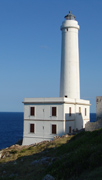
The lighthouse Faro della Palascìa, at approximately five kilometres (three miles) southeast of Otranto, marks the most easterly point of the Italian mainland.
About 50 kilometres (31 mi) south lies the promontory of Santa Maria di Leuca (so called since ancient times from its white cliffs, leukos being Greek for white), the southeastern extremity of Italy, the ancient Promontorium Iapygium or Sallentinum. The district between this promontory and Otranto is densely populated and very fertile.
The area that lies between Otranto and Santa Maria di Leuca is part of the Regional Natural Coastal Park of "Costa Otranto - Santa Maria di Leuca e Bosco di Tricase" wanted by the Apulia Region in 2008.
History
Otranto occupies the site of the ancient Greek city of Magna Graecia Hydrus (Greek Ὑδροῦς, stem Ὑδρουντ-) or Hydruntum (Latin), also known as Hydrunton, Hydronton, or Hydruntu. Otranto was a town of Messapian origin which sided against Rome in the wars of Pyrrhus and of Hannibal.
In Roman times it was a city. As it is the nearest port to the eastern coast of the Adriatic Sea, it was perhaps more important than Brundisium (present Brindisi), under the Roman emperors as a point of embarkation for the East, as the distance to Apollonia (in present Albania) was less than from Brundisium.
In the 8th century, it was for some time in the possession of duke Arechis II of Benevento.
On 17 August 928, the city was sacked by a Fatimid fleet under Sabir al-Fata. Its inhabitants were carried to North Africa as slaves. It remained in the hands of the Byzantine emperors until it was among the last cities of Apulia to surrender to the Norman Robert Guiscard in 1068. It then became part of the Principality of Taranto. In the Middle Ages, the Jews had a school there.
In 1480, Sultan Mehmed II sent an Ottoman fleet to invade Rome under the command of Gedik Ahmed Pasha. The force reached the shores of Apulia on 28 July 1480, and the city was captured in two weeks on 11 August 1480. The Muslim invaders had the commander of the defending force executed by being sawn in half and 800 residents were beheaded after refusing to convert to Islam. They were canonised by Pope Francis on 12 May 2013. Archbishop Stefano Pendinelli was also martyred.
Between August and September 1480, the Italian and European kingdoms failed to help King Ferdinand of Naples except for his cousin Ferdinand the Catholic of Spain, the Kingdom of Sicily and later the Republic of Genoa. In 1481, the Pope, in panic, called for a crusade to be led by King Ferdinand of Naples and was joined by troops of Hungarian king Matthias Corvinus. The Ottomans controlled the city for 13 months. Mehmed II died on his way to capture the rest of Italy. His successor, Sultan Bayezid II, ordered Gedik Ahmed Pasha to be hanged. On 11 September 1481, the Ottomans abandoned the city.
In 1537, the famous Ottoman corsair and admiral Barbarossa recaptured Otranto and the Fortress of Castro, but the Ottomans were again repulsed from the city and from the rest of Apulia. …
Main sights
Otranto main sights include:
The Castello Aragonese (Castle), reinforced by Emperor Frederick II and rebuilt by Alphonso II of Naples in 1485–98. It has an irregular plan with five sides, with a moat running along the entire perimeter. In origin it had a single entrance, reachable through a draw-bridge. Towers include three cylindrical ones and a bastion called Punta di Diamante ("Diamond's Head"). The entrance sports the coat of arms of Emperor Charles V.
The Cathedral, consecrated in 1088, a work of Count Roger I adorned later (about 1163), by Bishop Jonathas, with a mosaic floor; it has a rose window and side portal of 1481. The interior, a basilica with nave and two aisles, contains columns said to come from a temple of Minerva and a fine mosaic pavement of 1166, with interesting representations of the months, Old Testament subjects and others. Bones and relics of the Martyrs of Otranto, who perished in the 15th-century siege surround the high altar. The church has a crypt supported by 42 marble columns. The same Count Roger also founded a Basilian monastery here, which, under Abbot Nicetas, became a place of study; its library was nearly all bought by Bessarion.
The church of San Pietro, with Byzantine frescoes.
The catacombs of Torre Pinta.
Idro, a small river which the toponym Otranto stems from.
Culture
Otranto is the setting of Horace Walpole's book The Castle of Otranto, which is generally held to be the first Gothic novel. Walpole had chosen the town from a map of the Kingdom of Naples because the name was "well-sounding"; he was not aware that Otranto had a castle until 1786, some twenty-two years after the novel was first published under a pseudonym. The principal model for the castle was his villa in Strawberry Hill, London.
Otranto is also mentioned in Bram Stoker's novel The Lady of the Shroud.
Text from Wikipedia, the free encyclopedia, under CC BY-SA 4.0. Full article: «Otranto».
Photos
Getting there
OtrantoTrain, nearest
500 m as the crow flies
Otranto
Port700 m
Aeroporto "Fortunato Cesari"31.5 km
Distances are as the crow flies, not walking or driving.
Loading map…
Nearby
See on the mapMore historic villages in Puglia (Apulia)

- Most beautiful villages

- Most beautiful villages

- Most beautiful villages

- Most beautiful villages

- Most beautiful villages
Frequently asked questions
Where is Otranto?
Otranto is in Otranto, in the province of Lecce (Puglia (Apulia)), Italy. GPS coordinates: 40.14782, 18.48593.
What else is there to see near Otranto?
Nearby you’ll find: Castello di Otranto (700 m away), Torre del Serpe (1.8 km away), Torre dell'Orte (2.3 km away).
Sources and licences
Text. Wikipedia, the free encyclopedia (CC BY-SA 4.0).
Data. Wikidata (CC0); opening hours and contacts OpenStreetMap (ODbL).
Photos. Wikimedia Commons, author and licence on every image.
Credits for the 9 photos
- Otranto dal bastione dei Pelasgi — Freddyballo, CC BY-SA 3.0
- "Otranto eine kleine Hafenstadt mit wechselvoller Geschichte". 01 — Holger Uwe Schmitt, CC BY-SA 4.0
- 001 Piazza all'Umanità Migrante (Otranto), port, Torre Matta i muralla de mar — Enric, CC BY-SA 4.0
- 005 Port d'Otranto i muralla de mar, amb la Torre Matta i els Bastioni dei Pelasgi — Enric, CC BY-SA 4.0
- 009 Embarcació de salvament a la platja del port, vora la muralla de mar (Otranto) — Enric, CC BY-SA 4.0
- 020 Port esportiu d'Otranto, des de la Torre Matta — Enric, CC BY-SA 4.0
- 021 Via Bastioni dei Pelasgi (Otranto), des de la Torre Matta, al fons Punta Craulo — Enric, CC BY-SA 4.0
- 025 Muralla de mar i Via Bastioni dei Pelasgi (Otranto), des de la Torre Matta — Enric, CC BY-SA 4.0
- 026 La muralla de mar d'Otranto des de la Torre Matta, al fons Punta Craulo — Enric, CC BY-SA 4.0
Updated 28 October 2026. All sources and licences