
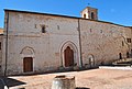


- Most beautiful villages
Photo: Hagai Agmon-Snir حچاي اچمون-سنير חגי אגמון-שניר, CC BY-SA 4.0 · Wikimedia Commons
Nocera Umbra is a town and comune in the province of Perugia, Italy, 15 kilometers north of Foligno, at an altitude of 520 m (1,710 ft) above sea-level.
The municipality, covering an area of 157.19 km2 (60.69 sq mi), is one of the largest in Umbria. It is one of I Borghi più belli d'Italia ("The most beautiful villages of Italy").
From the late 8th century BC, the area of present-day Nocera Umbra was occupied by an Umbrian community. This community was established across the territory, with burial areas at Portone and Boschetto–Ginepraia. The name nuvkri, attested in an Umbrian inscription, is generally connected with this settlement.
From the 3rd century BC, following the Battle of Sentinum and the opening of the Via Flaminia (222–220 BC), Nuceria developed in relation to this major route. The settlement became integrated into the Roman system and is recorded as a municipium within Regio VI, with its population divided into the groups of the Nucerini Camellani and the Nucerini Favonienses.
During the imperial period, the urban center was situated around the hill now occupied by the historic core of Nocera Umbra and extended into the adjacent northern plain. By the 3rd century AD, the town possessed a structured civic body, attested by the presence of an ordo decurionum.
Strabo describes Nocera as a very populous city of important position because it stood on the Via Flaminia, a road much frequented under the Romans. He also mentions the wooden vessels and utensils manufactured there. Claudius Ptolemy includes it among the colonies established by Augustus.
After the fall of the empire, it suffered during the barbarian invasions of the Goths and later the Lombards, who devastated it.
In 571 Nocera entered the Duchy of Spoleto.
In the 8th century Nocera formed part of the domains of the Church. Anastasius recounts that when Pope Stephen III appealed to Pepin against Aistulf, who had occupied various lands of the Church, the latter was compelled not only to restore those territories but also to return Nocera.
In the placitum of Duke Gisulf held at Rieti in 761, among the judges appears Eleuterio, gastald of Nocera.
In 824 Nocera became a county, as did the neighboring territories of Gualdo, Fossato, and Sigillo.
Around 1100 it developed into a self-governing town and joined the Guelph League, formed in 1154, in opposition to Gubbio. In 1198 it returned under Church rule. …
Text from Wikipedia, the free encyclopedia, under CC BY-SA 4.0. Full article: «Nocera Umbra».
Distances are as the crow flies, not walking or driving.


Nocera Umbra is in Nocera Umbra, in the province of Perugia (Umbria), Italy. GPS coordinates: 43.11128, 12.79009.
Nearby you’ll find: San Francesco (0 m away), Convento di Brogliano (11.3 km away), Eremo delle Carceri (12.4 km away).
Text. Wikipedia, the free encyclopedia (CC BY-SA 4.0).
Data. Wikidata (CC0); opening hours and contacts OpenStreetMap (ODbL).
Photos. Wikimedia Commons, author and licence on every image.
Updated 28 October 2026. All sources and licences