


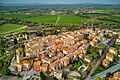


- Most beautiful villages
Photo: Hagai Agmon-Snir حچاي اچمون-سنير חגי אגמון-שניר, CC BY-SA 4.0 · Wikimedia Commons
Historic village
Italian comune
Deruta is a hill town and comune in the Province of Perugia in the Umbria region of central Italy.
Long known as a center of refined maiolica manufacture, Deruta remains known for its ceramics, which are exported worldwide. It is one of I Borghi più belli d'Italia ("The most beautiful villages of Italy").
Deruta is believed to have very ancient origins, with early names including Druida and later Perugia Vecchia. Historical accounts that it was founded by the Gauls or during the reign of Tarquinius Priscus lack evidence. The location of the modern town does not correspond exactly to the ancient settlement, which is thought to have been on a nearby hill where a few ruins, known as Perugia Vecchia, remain. By 1103 the three parishes already existed.
Deruta was first mentioned in the 12th century, when Perugia conquered it and established the town as a border fortress.
Pope Urban IV is said to have died in the area while returning from Todi, and his body was brought to Perugia.
Throughout the 14th and 15th centuries, Deruta experienced frequent changes of rulers, as well as repeated attacks and outbreaks of plague.
In 1391, due to ongoing conflicts among nearby cities including Assisi, Todi, Perugia, and Foligno, construction of a fortress began.
Braccio Fortebraccio attacked and devastated the surrounding village and entered the town, which was under siege; the walls were only restored in 1428.
Pope Eugene IV granted special privileges to Deruta and had the town re-fortified, parts of which remain today.
In 1500, Spanish forces passing through set fire to various houses, and the walls were restored again in 1523.
In the 16th century the town underwent reconstruction and revival under the Baglioni family. In 1534 Braccio Baglioni sacked Deruta. Later in the century the town aligned with the Church during the 1540 Salt War and was subsequently exempted from certain taxes.
Deruta remained under Papal control until 1860, except during periods of French rule from 1798 to 1800 under the Roman Republic and from 1809 to 1814 under Napoleon. In the mid-19th century the municipality had a population of 4,060 inhabitants. Of these, 1,408 lived in the main settlement, while 2,652 resided in the countryside.
In 1928 the frazione of Pomonte was separated from Deruta and transferred to the municipality of Gualdo Cattaneo.
Text from Wikipedia, the free encyclopedia, under CC BY-SA 4.0. Full article: «Deruta».
Distances are as the crow flies, not walking or driving.


Deruta is in Deruta, in the province of Perugia (Umbria), Italy. GPS coordinates: 42.98213, 12.41975.
Nearby you’ll find: Castello di Castelleone (2.8 km away), Museo dell'olivo e dell'olio (4.9 km away), Castello di Rosciano (5 km away).
Text. Wikipedia, the free encyclopedia (CC BY-SA 4.0).
Data. Wikidata (CC0); opening hours and contacts OpenStreetMap (ODbL).
Photos. Wikimedia Commons, author and licence on every image.
Updated 28 October 2026. All sources and licences