



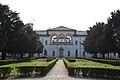


Photo: AlMo18, CC BY-SA 4.0 · Wikimedia Commons
At a glance
- Period
- Early modern period, 1764
- Architect
- Giuseppe Antonio Bianchi
- Protection
- Italian national heritage
- Coordinates
- 45°36′09″ N, 9°07′13″ E
- Address
- piazzetta delle Mimose, 3, 20812, Limbiate
About
No English description yet
Opening hours and directions are on this page. The full story is on Italian Wikipedia.
Read it in ItalianTimeline
- 1764Built
Events and people from Wikidata (CC0).
Photos
Getting there
Bovisio Masciago-MombelloTrain, nearest
1.9 km as the crow flies
Villa Medolago-Attanasiopiazzetta delle Mimose, 3, 20812, Limbiate
Aeroporto di Milano-Linate21.1 km
Distances are as the crow flies, not walking or driving.
Loading map…
Nearby
See on the mapMore historic villas and palaces in Lombardy


Frequently asked questions
Where is Villa Medolago-Attanasio?
Villa Medolago-Attanasio is in Limbiate, in the province of Monza e della Brianza (Lombardy), Italy. Address: piazzetta delle Mimose, 3, 20812, Limbiate. GPS coordinates: 45.60260, 9.12014.
How old is Villa Medolago-Attanasio?
Wikidata dates it to 1764.
What else is there to see near Villa Medolago-Attanasio?
Nearby you’ll find: Villa Mella (200 m away), Villa Pusterla (1.5 km away), Villa Borsani (2.3 km away).
Sources and licences
Data. Wikidata (CC0); opening hours and contacts OpenStreetMap (ODbL).
Photos. Wikimedia Commons, author and licence on every image.
Credits for the 2 photos
- Villa Attanasio-Medolago — AlMo18, CC BY-SA 4.0
- Villa Medolago, un passato da salvare — Simo.Albo80, CC BY-SA 4.0
Updated 28 October 2026. All sources and licences