

- UNESCO
- Free 1st Sunday
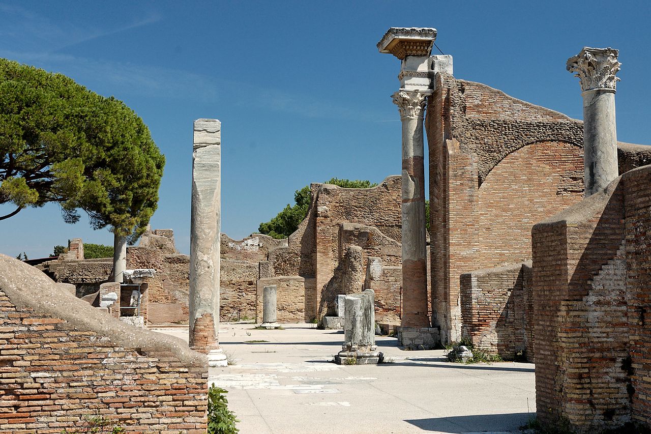
Photo: Marie-Lan Nguyen ( User:Jastrow ), CC BY 2.5 · Wikimedia Commons
Archaeological site, 7th century BC
Ancient Roman city and colony
Ostia Antica (lit. 'Ancient Ostia') is the modern name given to the ancient Roman city of Ostia. It became the port city of Rome located at the mouth of the Tiber and is near modern Ostia, 25 km (16 mi) southwest of Rome. Due to silting of the coastline from the river, the site now lies 3 km (2 mi) from the sea. The name Ostia (the plural of ostium) derives from Latin os 'mouth'.
The city continued to be prosperous into late antiquity despite harbour deterioration. After its abandonment, sand dunes covered the site and aided the city's preservation, which is surpassed only by Pompeii and Herculaneum.
Ostia Antica is now a large archaeological site noted for the excellent preservation of its ancient buildings, magnificent frescoes and impressive mosaics. As in Pompeii, Ostia's remains provide details about Roman urbanism that are not accessible within the city of Rome itself.
Ostia may have been Rome's first colony. According to legend, Ancus Marcius, the fourth king of Rome, was the first to destroy Ficana, an ancient town that was only 17 km (11 mi) from Rome and had a small harbour on the Tiber, and then proceeded with establishing the new colony 10 km (6 mi) further west and closer to the sea coast. An inscription seems to confirm the establishment of the old castrum (military camp) of Ostia in the 7th century BC. The oldest archaeological remains so far discovered date back to only the 4th century BC. The most ancient buildings currently visible are from the 3rd century BC, notably the Castrum; of a slightly later date is the Capitolium (temple of Jupiter, Juno and Minerva).
Ostia probably developed as a naval base and in 267 BC, during the First Punic War, it was the seat of the quaestor Ostiensis in charge of the fleet. It had an important commercial and military role during the Second Punic War, so that it obtained exemption from military service for its inhabitants.
During the 2nd century BC its role as a commercial port for the import of grain to Rome gradually became prevalent and buildings began to spread outside the castrum. The ancient dock on the right bank of the river became insufficient for the growing needs of Rome, so that the praetor Gaius Caninius appropriated a large portion of land on the left bank for new docks.
As the city of Rome grew, Ostia did not have the capacity to supply all its needs and Puteoli became the major port of Rome, despite being located 240km from the capital.
Ostia was a scene of fighting during the period of civil wars in the 80s BC. In 87 BC Marius attacked the city in order to cut off the flow of trade to Rome, aided by his generals Cinna, Carbo and Sertorius, and captured the city and plundered it.
In 68 BC, the town was sacked by pirates, who set the port on fire, destroyed the consular war fleet, and kidnapped two prominent senators. This attack caused such panic in Rome that Pompey the Great arranged for the tribune Aulus Gabinius to pass a law, the lex Gabinia, to allow Pompey to raise an army and destroy the pirates. Within a year, the pirates had been defeated.
The town was then re-built and provided with defensive walls started under Marcus Tullius Cicero according to an inscription. …
The republican castrum at the core of the settlement had a typical rectangular plan built on two main roads that crossed at right angles in the centre: the cardo and the decumanus maximus, the latter on the route of the Via Ostiense coming from Rome. The cardo and the decumanus exited the walls of the castrum through four gates. Its walls are just over 1.5 m thick in square blocks of Fidene tuff arranged irregularly. Sections of the walls have been reused on the eastern side as a back wall of a building with taverns (I,I,4) and inside the Small Market (I,VIII,1), the Horrea epagathiana (I,VIII,3) and the building at (I,VIII,10).
Immediately outside the southern gate the cardo turned southwest on the route of the ancient coastal road towards Laurentum (which later became a section of the Via Severiana). Immediately after the western gate, the decumanus turned southeast, heading directly towards the beach then not far away. The subsequent expansion of the city outside the walls of the castrum followed these routes, giving a disorderly appearance to the urban plan.
Inside the city, another important road was the Via Semita dei cippi, from the cippi (stones) on which was the Semitic inscription hor(reorum) (warehouses) where the grain was stored; the road directly connected the decumanus maximus to the Laurentina gate (its continuation on the opposite side of the decumanus towards the river has the modern name of Via dei Molini).
From the 1st century AD, the area between the walls of Porta Marina and the nearby sea coast had much multifunctional construction so that next to religious buildings, such as the sanctuary of Bona Dea, there are the Domus Fulminata, the mausoleum of the Gamala and commercial premises, such as the Caupona of the god Pan. In the Trajan and Hadrianic eras this area was divided into lots and, among other buildings, the Terme della Marciana and the Terme del Sileno were built; this entire coastal area was served by a coastal road used for local traffic which was paved in the Severan era. …
South of Ostia many rich villa-estates were developed from the Republican era along the coast road to Laurentum. Pliny described the route towards his villa there: “There are two different roads to it: if you go by that of Laurentum, you must turn off at the fourteenth mile-stone; if by that of Ostia, at the eleventh. Both of them are sandy in places, which makes it a little heavier and longer by carriage, but short and easy on horseback. The landscape affords plenty of variety, the view in some places being closed in by woods, in others extending over broad meadows, where numerous flocks of sheep and herds of cattle, which the severity of the winter has driven from the mountains, fatten in the spring warmth, and on the rich pasturage”.
Today several well-preserved Roman villas south of Ostia have been excavated in the area of Castel Fusano, including the Villa della Palombara excavated in 1989–2008.
The remains were used over the centuries as a quarry for marble for the palazzi built in Rome.
The Papacy started organising its own digs for sculptures with Pope Pius VII.
Under Benito Mussolini massive excavations were undertaken from 1939 to 1942 during which several remains, particularly from the Republican Period, were brought to light. These were interrupted when Italy became a major battlefield of World War II.
In the post-war period, the first volume of the official series Scavi di Ostia appeared in 1954; it was devoted to a topography of the town by Italo Gismondi and after a hiatus the research still continues today. Though untouched areas adjacent to the original excavations were left undisturbed awaiting a more precise dating of Roman pottery types, the "Baths of the Swimmer", named for the mosaic figure in the apodyterium, were meticulously excavated, in 1966–70 and 1974–75, in part as a training ground for young archaeologists and in part to establish a laboratory of well-understood finds as a teaching aid.
It has been estimated that two-thirds of the ancient town are as yet unexcavated.
In 2014, a geophysical survey using magnetometry, among other techniques, revealed the existence of a boundary wall on the north side of the Tiber enclosing an unexcavated area of the city containing three massive warehouses.
In 2025, excavations at Ostia Antica uncovered what may be the oldest Jewish ritual bath (mikveh) found outside Israel, dating to the late 4th or early 5th century. Located within a large Roman house, the bath features a deep immersion pool and an oil lamp with a menorah symbol, supporting its Jewish identification.
Text from Wikipedia, the free encyclopedia, under CC BY-SA 4.0. Full article: «Ostia».
Events and people from Wikidata (CC0).
Distances are as the crow flies, not walking or driving.


Ostia is in Fiumicino, in the province of Roma (Lazio), Italy. GPS coordinates: 41.75417, 12.28750.
According to OpenStreetMap the opening hours are: 29 October to 15 February: 8:30–16:30; 16 February to 15 March: 8:30–17:00; 16 March to 24 March: 8:30–17:30; 25 March to 31 August: 8:30–19:15; 1 September to 30 September: 8:30–19:00; 1 October to 28 October: 8:30–18:30. Always check the official website before your visit.
Yes: entry is free on the first Sunday of every month, under the Italian “Domenica al museo” scheme.
According to OpenStreetMap data, the site is not wheelchair accessible.
Wikidata dates it to the 7th century BC.
Nearby you’ll find: Caseggiato del Larario (0 m away), Curia (Ostia) (0 m away), Horrea Epagathiana et Epaphrodithiana (0 m away).
Text. Wikipedia, the free encyclopedia (CC BY-SA 4.0).
Data. Wikidata (CC0); opening hours and contacts OpenStreetMap (ODbL).
Photos. Wikimedia Commons, author and licence on every image.
Updated 28 October 2026. All sources and licences