






Photo: Robertk9410, CC BY-SA 4.0 · Wikimedia Commons
At a glance
- Type
- Fortress / Tower
- Period
- Modern era, 1911
- Protection
- Italian national heritage
- Coordinates
- 45°56′43″ N, 11°39′46″ E
- Address
- Via Monte Lisser
History and description
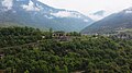
Fort Lisser, also known as Fort Monte Lisser, is an Italian fortification built on the eastern end Altopiano dei Sette Comuni (Plateau of 7 Communities) on Monte Enego. Lisser was built at the peak of the mountain, which is an altitude of 1633m (5400ft). Fort Lisser is part of the Brenta-Cismon barrier in Northern Italy. The fort was tasked with preventing an attack down the Valsugana Valley. Lisser was built between 1911 and 1912.
Construction
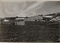
The fort consisted of a 2 story building not too dissimilar to the forts of the Lavarone-Folgaria group on the other side of the border. Fort Lisser was relatively well equipped when compared to other Italian forts. Lisser was equipped with a kitchen, storerooms, multiple ammo magazines, an ammunition hoist, a generator, a ventilation and air filter system, heating, large cisterns for water, and accommodations for both officers and enlisted men.
World War I
The fort was quiet until 12:20pm on June 8, 1916, when during the Battle of Asiago, 3 of the fort’s cupolas were struck by 305mm Mörsers. Despite being able to occupy the fort, the Austro-Hungarians decided not to because the fort was unusable. After the Battle of Caporetto in the autumn of 1917, the fort was occupied by the Austro-Hungarians without firing a shot.
Text from Wikipedia, the free encyclopedia, under CC BY-SA 4.0. Full article: «Forte Lisser».
Timeline
- 1911Built
Events and people from Wikidata (CC0).
Photos
Getting there
PrimolanoTrain, nearest
3.7 km as the crow flies
Forte LisserVia Monte Lisser
Distances are as the crow flies, not walking or driving.
Loading map…
Nearby
See on the mapMore fortresses and towers in Veneto


Frequently asked questions
Where is Forte Lisser?
Forte Lisser is in Enego, in the province of Vicenza (Veneto), Italy. Address: Via Monte Lisser. GPS coordinates: 45.94514, 11.66287.
How old is Forte Lisser?
Wikidata dates it to 1911.
What else is there to see near Forte Lisser?
Nearby you’ll find: Forte Coldarco (3.1 km away), Tagliata della Scala (4.4 km away), Forte Tagliata delle Fontanelle (4.6 km away).
Sources and licences
Text. Wikipedia, the free encyclopedia (CC BY-SA 4.0).
Data. Wikidata (CC0); opening hours and contacts OpenStreetMap (ODbL).
Photos. Wikimedia Commons, author and licence on every image.
Credits for the 9 photos
- Forte Lisser - casematta principale e fronte di gola — Robertk9410, CC BY-SA 4.0
- Forte Lisser - cupole corazzate — Robertk9410, CC BY-SA 4.0
- Forte Lisser - panoramio (1) — ЭЯMДИИФ БIFFI, CC BY-SA 3.0
- Forte Lisser - torretta corazzata a scomparsa — Robertk9410, CC BY-SA 4.0
- Forte Lisser 2017 — Robertk9410, CC BY-SA 4.0
- Monte Lisser, olasz páncélerőd. Fortepan 52319 — FOTO:Fortepan — ID 52319:, Adományozó/Donor: Komlós Péter., archive copy at the Wayback Machine, Public domain
- Esterno forte — Antonio Cunico, CC BY-SA 4.0
- Interno forte — Antonio Cunico, CC BY-SA 4.0
- Monte Lisser .Werk Lisser. (BildID 15641673) — K.u.k. Kriegspressequartier, Lichtbildstelle - Wien, Public domain
Updated 28 October 2026. All sources and licences