


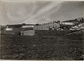


Photo: Syrio, CC BY-SA 4.0 · Wikimedia Commons
Fortress / Tower
Forte Tagliata delle Fontanelle
Building in Cismon del Grappa, Italy
At a glance
- Type
- Fortress / Tower
- Coordinates
- 45°58′01″ N, 11°42′50″ E
History and description
Fort Tagliata Delle Fontanelle, also known as the Fontanelle Cut, is an Italian fortification built around 1910. Fontanelle was built above the village of Primolano in the Valsugana Valley. Fontanelle's main purpose was to block an enemy infiltration from the Valsugana towards the town of Feltre. The fort was built on 2 levels, and was made out of stone blocks. The fort has a deep frontal moat that is relatively unchanged today, unlike the rest of the fort, which is unrecognizable compared to its former self. Fontanelle was also connected to Forte Tagliata della Scala roadblock by a caponier. Fontanelle was armed with 2 12cm howitzers and 2 87mm field-guns.
World War I
Fort Tagliata Delle Fontanelle saw very little of the war due to being behind the lines a decent bit. The only brush with war Fontanelle got was when Italian troops abandoned it in the autumn of 1917, after the disastrous Battle of Caporetto.
Text from Wikipedia, the free encyclopedia, under CC BY-SA 4.0. Full article: «Forte Tagliata delle Fontanelle».
Photos
Getting there
PrimolanoTrain, nearest
1.0 km as the crow flies
Forte Tagliata delle Fontanelle
Distances are as the crow flies, not walking or driving.
Loading map…
Nearby
See on the mapMore fortresses and towers in Veneto


Frequently asked questions
Where is Forte Tagliata delle Fontanelle?
Forte Tagliata delle Fontanelle is in Valbrenta, in the province of Vicenza (Veneto), Italy. GPS coordinates: 45.96697, 11.71397.
What else is there to see near Forte Tagliata delle Fontanelle?
Nearby you’ll find: Tagliata della Scala (300 m away), Forte Coldarco (1.5 km away), Covolo di Butistone (2.2 km away).
Sources and licences
Text. Wikipedia, the free encyclopedia (CC BY-SA 4.0).
Data. Wikidata (CC0); opening hours and contacts OpenStreetMap (ODbL).
Photos. Wikimedia Commons, author and licence on every image.
Credits for the 2 photos
- Tagliata delle Fontanelle — Syrio, CC BY-SA 4.0
- Tagliata delle Fontanelle 01 — Syrio, CC BY-SA 4.0
Updated 28 October 2026. All sources and licences