




Photo: Syrio, CC BY-SA 4.0 · Wikimedia Commons
Fortress / Tower, 1892
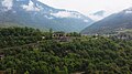
Tagliata della Scala
Fort in Valbrenta, Italy
At a glance
- Type
- Fortress / Tower
- Period
- Modern era, 1892
- Protection
- Italian national heritage
- Coordinates
- 45°57′56″ N, 11°42′40″ E
- Address
- Via per Belluno, 5
About
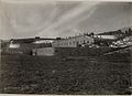
Fort Tagliata Della Scala, also known as the Scala Cut, is an Italian fortification located overlooking the town of Primolano in the Valsugana Valley in Northern Italy. As soon as the area near Primolano was incorporated into the Italian empire in 1866, the need for fortifications to guard the Brenta Canal was realized. Scala is part of the Brenta-Cismon Barrier of fortifications along the Austro-Hungarian border. The fort was built between 1892 and 1904, and was built out of stone, weakening it in the future. Scala was built with two floors, one of which was partially underground, of which the underground floor has eight rooms. The fort is connected to Forte Tagliata delle Fontanelle by a postern.
Text from Wikipedia, the free encyclopedia, under CC BY-SA 4.0. Full article: «Tagliata della Scala».
Timeline
- 1892Built
Events and people from Wikidata (CC0).
Photos
Getting there
PrimolanoTrain, nearest
800 m as the crow flies
Tagliata della ScalaVia per Belluno, 5
Distances are as the crow flies, not walking or driving.
Loading map…
Nearby
See on the mapMore fortresses and towers in Veneto


Frequently asked questions
Where is Tagliata della Scala?
Tagliata della Scala is in Valbrenta, in the province of Vicenza (Veneto), Italy. Address: Via per Belluno, 5. GPS coordinates: 45.96563, 11.71102.
How old is Tagliata della Scala?
Wikidata dates it to 1892.
What else is there to see near Tagliata della Scala?
Nearby you’ll find: Forte Tagliata delle Fontanelle (300 m away), Forte Coldarco (1.3 km away), Covolo di Butistone (2.2 km away).
Sources and licences
Text. Wikipedia, the free encyclopedia (CC BY-SA 4.0).
Data. Wikidata (CC0); opening hours and contacts OpenStreetMap (ODbL).
Photos. Wikimedia Commons, author and licence on every image.
Credits for the 9 photos
- Tagliata della Scala by drone 01 — Syrio, CC BY-SA 4.0
- Tagliata della Scala 01 — Syrio, CC BY-SA 4.0
- Tagliata della Scala by drone 02 — Syrio, CC BY-SA 4.0
- Fort Primolano. (BildID 15667246) — K.u.k. Kriegspressequartier, Lichtbildstelle - Wien, Public domain
- Sperrfort oberhalb Primolano. Munitions-Tragtierkolonne. (BildID 15635325) — K.u.k. Kriegspressequartier, Lichtbildstelle - Wien, Public domain
- Straßensperre bei Primolano. (BildID 15417809) — K.u.k. Kriegspressequartier, Lichtbildstelle - Wien, Public domain
- Talsperre Primolano. Generaloberst Scheuchenstuel im Auto passiert die Talsperre. (BildID 15635388) — K.u.k. Kriegspressequartier, Lichtbildstelle - Wien, Public domain
- Talsperre Primolano.Hof des Werkes. (BildID 15635409) — K.u.k. Kriegspressequartier, Lichtbildstelle - Wien, Public domain
- Talsperre Primolano.Interieur vom Werk Primolano nach der Sprengung. (BildID 15635395) — K.u.k. Kriegspressequartier, Lichtbildstelle - Wien, Public domain
Updated 28 October 2026. All sources and licences