


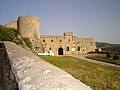


Photo: ALC, CC BY-SA 4.0 · Wikimedia Commons
At a glance
- Type
- Archaeological site
- Coordinates
- 41°12′32″ N, 15°13′48″ E
About
No English description yet
Opening hours and directions are on this page. The full story is on Italian Wikipedia.
Read it in ItalianPhotos
Getting there
Montaguto-PanniTrain, nearest
3.0 km as the crow flies
Ferrara
Aeroporto di Foggia "Gino Lisa"35.6 km
Distances are as the crow flies, not walking or driving.
Loading map…
Nearby
See on the mapMore archaeological sites in Campania

- UNESCO
- Free 1st Sunday

- UNESCO

- UNESCO

- UNESCO
- Free 1st Sunday

- Free 1st Sunday
Frequently asked questions
Where is Ferrara?
Ferrara is in Savignano Irpino, in the province of Avellino (Campania), Italy. GPS coordinates: 41.20887, 15.23004.
What else is there to see near Ferrara?
Nearby you’ll find: Savignano Irpino (4.8 km away), Saint Angel de Ursaria abbey (8.5 km away), Zungoli (9.4 km away).
Sources and licences
Data. Wikidata (CC0); opening hours and contacts OpenStreetMap (ODbL).
Photos. Wikimedia Commons, author and licence on every image.
Credits for the 3 photos
- Monte Castello Ferrara - Savignano Irpino — ALC, CC BY-SA 4.0
- Chiesetta Santa Sofia alla Ferrara - Savignano Irpino — ALC, CC BY-SA 4.0
- Difesa Ferrara highlands - Savignano Irpino — ALC, CC BY-SA 4.0
Updated 28 October 2026. All sources and licences