





Photo: Unknown author Unknown author, Public domain · Wikimedia Commons
Fortress / Tower, 1860
Fort Rocchetta
Building in Ton, Trentino, Italy
Ton (TN), Trentino-South Tyrol
At a glance
- Type
- Fortress / Tower
- Period
- Modern era, 1860
- Coordinates
- 46°14′02″ N, 11°04′05″ E
History and description
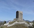
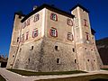
The Rocchetta Barrage is a mid 19th century fort built to protect what was at the time the Austro-Hungarian city of Trento. The fort was built between 1860-64, as part of the first generation of Austro-Hungarian fortifications built to protect Trento from the Italian state of Lombardy. The fort features a road cut to protect Trento from an attack through the Tonale Pass. The fort was built mainly facing the Non Valley, barring the way to Trento. The fort had 11 16cm M61 casemate cannons, with 8 oriented towards the Non Valley, and 3 oriented towards the plain of Mezzolombardo. Rocchetta was crewed by 25 men from the fortress of Trento.
World War I
The fort was well kept before the war, but by late 1915 the Austro-Hungarian high command realized that an Italian breakthrough was less and less likely and the fort was downgraded, its main armament moved to more active fronts and the fort became a supply depot.
Post-war
After the war the Italian government used the fort as a powder magazine and storage for half a million Austro-Hungarian grenades with the intent of disarming the grenades. On Dec. 27, 1922, probably due to the mis-handling of explosives, the fort was rocked by a tremendous explosion that killed 6 workers and 1 soldier of 18th Infantry Regiment “Brigade Aqui”, and blew away the lower part of the fort and the passing road. On Sept. 22, 1927, Rocchetta was discharged from military service. 2 years later Rocchetta was demolished to widen the road passing below. Today, the remains of the fort are located in the La Rocchetta Biotope.
Text from Wikipedia, the free encyclopedia, under CC BY-SA 4.0. Full article: «Fort Rocchetta».
Timeline
- 1860Built
Events and people from Wikidata (CC0).
Photos
Getting there
Masi di VigoTrain, nearest
700 m as the crow flies
Fort Rocchetta
Aeroporto di Bolzano-Dolomiti - Flughafen Bozen-Dolomiten31.9 km
Distances are as the crow flies, not walking or driving.
Loading map…
Nearby
See on the mapMore fortresses and towers in Trentino-South Tyrol


Frequently asked questions
Where is Fort Rocchetta?
Fort Rocchetta is in Ton, in the province of Trento (Trentino-South Tyrol), Italy. GPS coordinates: 46.23389, 11.06806.
How old is Fort Rocchetta?
Wikidata dates it to 1860.
What else is there to see near Fort Rocchetta?
Nearby you’ll find: Torre di Visione (200 m away), Castel Belasi (2.7 km away), Castel Sporo (3.1 km away).
Sources and licences
Text. Wikipedia, the free encyclopedia (CC BY-SA 4.0).
Data. Wikidata (CC0); opening hours and contacts OpenStreetMap (ODbL).
Photos. Wikimedia Commons, author and licence on every image.
Credits for the 3 photos
- Sperre Rochetta — Unknown author Unknown author, Public domain
- Fort Rocchetta 4D (view 1) — Cicero Moraes (Arc-Team) - 3D reconstruction; Alessandro Bezzi and Luca Bezzi (Arc-Team) - archaeological research; Rupert Gietl (Arc-Team) - historical research, CC BY 4.0
- Survey presso i ruderi del Forte Rocchetta — Luca Bezzi (Arc-Team), CC BY 4.0
Updated 28 October 2026. All sources and licences