




- Most beautiful villages
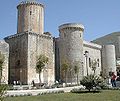
Photo: Orcovolante, CC BY-SA 3.0 · Wikimedia Commons
Pico is a town and comune in the province of Frosinone, in the Lazio region of central Italy. It is bounded by other comunes of San Giovanni Incarico, Campodimele, Pontecorvo, Pastena and Lenola.
It is part of the Comunità Montana Monti Ausoni. Sights include the Farnese castle, founded around the 11th century AD. It is one of I Borghi più belli d'Italia ("The most beautiful villages of Italy").
Text from Wikipedia, the free encyclopedia, under CC BY-SA 4.0. Full article: «Pico».
Distances are as the crow flies, not walking or driving.


Pico is in Pico, in the province of Frosinone (Lazio), Italy. GPS coordinates: 41.45139, 13.56167.
Nearby you’ll find: Museo della Civiltà contadina e dell'Ulivo (6.2 km away), Fregellae (9.7 km away), Roccaguglielma (12.6 km away).
Text. Wikipedia, the free encyclopedia (CC BY-SA 4.0).
Data. Wikidata (CC0); opening hours and contacts OpenStreetMap (ODbL).
Photos. Wikimedia Commons, author and licence on every image.
Updated 28 October 2026. All sources and licences