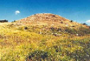


Photo: Original uploader was Utente:RobertoVito at it.wikipedia, CC BY-SA 3.0 · Wikimedia Commons
At a glance
- Type
- Archaeological site
- Elevation
- 879 m above sea level
- Coordinates
- 40°24′43″ N, 15°21′46″ E
About
Monte Pruno is a mountain in the southern Cilento region of the Province of Salerno, in the Campania region, of southern Italy. It is 879 metres (2,884 ft) above sea level.
Text from Wikipedia, the free encyclopedia, under CC BY-SA 4.0. Full article: «Monte Pruno».
Photos
Getting there
AulettaTrain, nearest
14.9 km as the crow flies
Monte Pruno
Distances are as the crow flies, not walking or driving.
Loading map…
Nearby
See on the mapMore archaeological sites in Campania

- UNESCO
- Free 1st Sunday

- UNESCO

- UNESCO

- UNESCO
- Free 1st Sunday

- Free 1st Sunday
Frequently asked questions
Where is Monte Pruno?
Monte Pruno is in Roscigno, in the province of Salerno (Campania), Italy. GPS coordinates: 40.41183, 15.36282.
What else is there to see near Monte Pruno?
Nearby you’ll find: Natural History Museum of Alburni (3.2 km away), Castello di Magliano Nuovo (12.2 km away), Castelcivita Caves (16 km away).
Sources and licences
Text. Wikipedia, the free encyclopedia (CC BY-SA 4.0).
Data. Wikidata (CC0); opening hours and contacts OpenStreetMap (ODbL).
Photos. Wikimedia Commons, author and licence on every image.
Credits for the 2 photos
- Monte Pruno Roscigno — Original uploader was Utente:RobertoVito at it.wikipedia, CC BY-SA 3.0
- Tracciato Via degli Stranieri - Monte Pruno - zona archeologica - Roscigno (Sa) - Italia — Roberto Vito Gerardo, CC0
Updated 28 October 2026. All sources and licences