



- UNESCO
- Free 1st Sunday
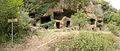
Photo: Robin Iversen Rönnlund, CC BY-SA 3.0 · Wikimedia Commons
Archaeological site
An archaeological site on the Mignone river in Italy with evidence for human settlement in the prehistoric period, the Iron Age (Etruscan culture), and the Medieval period
Monte Romano (VT), Lazio
Opening hours and directions are on this page. The full story is on Italian Wikipedia.
Read it in ItalianOur data shows no stations, stops or car parks nearby. Check how to get there before you set out.


Luni sul Mignone is in Monte Romano, in the province of Viterbo (Lazio), Italy. GPS coordinates: 42.22579, 11.93302.
According to OpenStreetMap data, the site is not wheelchair accessible.
Nearby you’ll find: San Giovenale (5.5 km away), Monte Rovello (6.7 km away), Cencelle (7 km away).
Data. Wikidata (CC0); opening hours and contacts OpenStreetMap (ODbL).
Photos. Wikimedia Commons, author and licence on every image.
Updated 28 October 2026. All sources and licences