


- UNESCO
- Free 1st Sunday
Archaeological site, Cori (LT)
41°38′33″ N, 12°54′56″ E
No photo on Wikimedia Commons yet
Cori (ancient Cora) is a city and comune in the province of Latina, in the Lazio region of central Italy.
Cora was well developed in the age of the expansion of Rome (7th-6th century BC). It is recorded as being part of the Latin League. According to Livy, in 503 BC it sought unsuccessfully to revolt against the Roman Republic, together with Suessa Pometia, and with the assistance of the Aurunci. By 495 BC Cora and Pometia are said by Livy to have been Volscian towns. Upon hearing of Volscian attempts to foment war, the Roman army marched against the Volsci, and in order to avoid war the Volsci offered three hundred children of the leading men of Cora and Suessa Pometia as hostages. War nevertheless broke out later in the year. It is unclear what happened to the hostages.
Coins of Cora exist, belonging at latest to 350–250 BC. Cora became a Roman possession after the Social War (90–88 BC), maintaining some administrative and political autonomy, and before the end of the Republic it had become a municipium.
Cori suffered a steep decline in the early centuries of the Middle Ages. It was often allied with its neighbour Velletri. It was a possession of the Annibaldi until 1234, when it went back to the Papal suzerainty, under which (apart from a short period under Ladislaus of Naples in 1400–10) it remained until the unification of Italy.
It has been part of the province of Latina since 1934.
The hilly region of Cori is permitted to produce both red and white Italian DOC wine, with the region producing more white wines. Grapes are limited to a harvest yield of 16 tonnes/ha with finished white wines needing a minimum alcohol level of 11% and finished reds needing 11.5%. The white wines are a blend of up to 70% Malvasia di Candia, up to 40% Trebbiano and up to 30% Bellone and Giallo. The reds are composed of 40-60% Montepulciano and 20-40% Nero Buono, 10-30% Cesanese.
The Temple of Hercules, early 1st century BC. It is a national monument of Italy.
Church of Santa Oliva, built in 1467–85 over a Roman temple dedicated to Janus. In the apse is a fresco of Pinturicchio's school. Annexed is a cloister from 1480. Nearby are the remains of the Temple of Castor and Pollux (a 1st-century BC restoration of the 5th-century BC sanctuary).
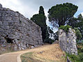
Polygonal walls
Ponte della Catena ("Chain Bridge"), of Roman origin.
Oratory of SS. Annunziata, with frescos.
Church of St. John the Baptist (16th century).
Text from Wikipedia, the free encyclopedia, under CC BY-SA 4.0. Full article: «Cora».
Distances are as the crow flies, not walking or driving.
 Things to see in Cori10,366 inhabitants, 384 m above sea level. 11 historic places in the town.PhotoPatafisik, CC BY-SA 3.011 places
We are missing the opening hours and photos. The data comes from open projects: if you add it there, it appears here at the next update.


Cora is in Cori, in the province of Latina (Lazio), Italy. GPS coordinates: 41.64255, 12.91567.
Nearby you’ll find: Cappella Annunziata (700 m away), Palazzo Salviati (5.9 km away), Norba (6.8 km away).
Text. Wikipedia, the free encyclopedia (CC BY-SA 4.0).
Data. Wikidata (CC0); opening hours and contacts OpenStreetMap (ODbL).
Updated 28 October 2026. All sources and licences