
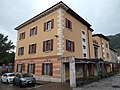


Photo: Llorenzi, CC BY-SA 3.0 · Wikimedia Commons
Fortress / Tower, 1868
Fortified building of Civezzano
Austro-Hungarian control fortification in Civezzano, Trento, Italy
At a glance
- Type
- Fortress / Tower
- Period
- Modern era, 1868
- Protection
- Italian national heritage
- Coordinates
- 46°05′06″ N, 11°10′30″ E
- Address
- Strada provinciale 17 "Strada dei Forti"
History and description
The Civezzano Fortified Complex is an Austro-Hungarian fortification built to the East of the Northern Italian city of Trento. Built between 1868 and 1876, it was part of the second group of fortifications built around Trento.
Civezzano Alto “Fort Proper”
Civezzano Alto was built between 1868 and 1876 to guard the Northern Italian city of Trento from an attack from the east. Alto was built vertically into the mountain because of the lack of flat space, and was built with 2 levels and had minimum gun ports on each level. The fort was built on top of a Roman castle, which was built upon during the middle ages, becoming a real castle until it was destroyed in 1254. The fort was armed with 5 15cm M61 fortress guns, and 3 12cm howitzers. The fort was surrounded by a ditch on the front and left sides, in addition to a heavy concentration of barbed wire. The wartime garrison was estimated to be 3 officers and 138 enlisted men. By 1915, the Austrians destroyed the fort and its armament moved elsewhere.
Upper road block
The upper road block is a single-story masonry structure now located on the road from Civezzano to Cognola. Since the Upper roadblock was built between 1868 and 1872, Upper was part of the second round of fortifications built around Trento. The fort was renovated in 1914, just before World War I. The works consisted of a battery of cannons built into casemates surrounded by dry ditches with rifle loopholes covering the road, ditches, and the entrance to the fort. The upper road block's main armament was far more modest that the fort proper, it consisted of 2 12cm M61 fortress cannons, all facing towards Pergine. In times of war the fort's complement would be 48 enlisted men. The upper road block was connected to the lower road block by a trench. Upper is the only fortification that shows the transition between the conventional 1800s fortification and the heavily armed and armored fort of the "Vogl" style. After World War I, the fort was used as a powder keg until 1956, when it was sold to the Municipality of Civezzano, and finally it underwent renovations in 2016.
Lower road block
The lower road block was built into the rock on the side of the "Croatian" road near Civezzano. Lower was built between 1868 and 1876. 2 gunports were carved into the rock on the side of the road, a new innovation for the Austro-Hungarians. A 3rd gunport was carved in 1897, alongside the building of an infantry fort to guard the Valsugana railway. An iron door physically blocked the area where the Fersina Gorge narrows. The fort was armed with 2 12cm guns and 3 7cm M95 K.K field cannons, all mounted in casemates facing towards Civezzano. This part of the fortification was the only to not be disarmed by 1898, which at that time sported 3 7cm guns mounted in the caves. Lower was the only fortification in the ring of fortifications around Trento to remain in use during World War I.
Text from Wikipedia, the free encyclopedia, under CC BY-SA 4.0. Full article: «Fortified building of Civezzano».
Timeline
- 1868Built
Events and people from Wikidata (CC0).
Photos
Getting there
Povo-MesianoTrain, nearest
3.3 km as the crow flies
Fortified building of CivezzanoStrada provinciale 17 "Strada dei Forti"
Distances are as the crow flies, not walking or driving.
Loading map…
Nearby
See on the mapMore fortresses and towers in Trentino-South Tyrol


Frequently asked questions
Where is Fortified building of Civezzano?
Fortified building of Civezzano is in Civezzano, in the province of Trento (Trentino-South Tyrol), Italy. Address: Strada provinciale 17 "Strada dei Forti". GPS coordinates: 46.08489, 11.17487.
How old is Fortified building of Civezzano?
Wikidata dates it to 1868.
What else is there to see near Fortified building of Civezzano?
Nearby you’ll find: Ecomuseo Argentario (700 m away), Forte Roncogno (1.7 km away), Castel Seregnano (2.2 km away).
Sources and licences
Text. Wikipedia, the free encyclopedia (CC BY-SA 4.0).
Data. Wikidata (CC0); opening hours and contacts OpenStreetMap (ODbL).
Photos. Wikimedia Commons, author and licence on every image.
Credits for the 5 photos
- Complesso fortificato di Civezzano - Tagliata stradale superiore 05 — Llorenzi, CC BY-SA 3.0
- Complesso fortificato di Civezzano - Tagliata stradale superiore 04 — Llorenzi, CC BY-SA 3.0
- Forte Civezzano 01 — Llorenzi, CC BY-SA 4.0
- Tagliata stradale inferiore di Civezzano 01 — Llorenzi, CC BY-SA 4.0
- Tagliata stradale superiore di Civezzano 01 — Llorenzi, CC BY-SA 4.0
Updated 28 October 2026. All sources and licences