Saved

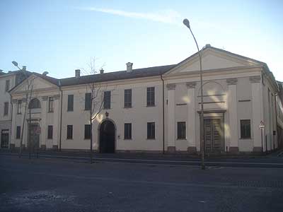
Abbey / Monastery, Vertemate con Minoprio (CO)

45°43′54″ N, 9°05′04″ E

No photo on Wikimedia Commons yet

Upload a photo to Commons

Abbey / Monastery, 1084

Abbazia di San Giovanni

Church building in Vertemate con Minoprio, Italy

Vertemate con Minoprio (CO), Lombardy

Directions

At a glance

Period
Middle Ages, 1084
Style
Romanesque architecture
Dedicated to
John the Baptist
Protection
Italian national heritage
Coordinates
45°43′54″ N, 9°05′04″ E
Address
Via Abbazia

About

No English description yet

Opening hours and directions are on this page. The full story is on Italian Wikipedia.

Read it in Italian

Timeline

  1. 1084Built

Events and people from Wikidata (CC0).

Getting there

CucciagoTrain, nearest
1.0 km as the crow flies
Abbazia di San GiovanniVia Abbazia
Pontile 59.1 km
Aeroporto internazionale Milano Malpensa "Silvio Berlusconi"30.1 km

Distances are as the crow flies, not walking or driving.

Loading map…

Do you know this place?

We are missing the opening hours, a description and photos. The data comes from open projects: if you add it there, it appears here at the next update.

More abbeys and monasteries in Lombardy

  • UNESCO
Abbey / Monastery

Torba Abbey

Gornate-Olona (VA)

Opening hours
  • Free 1st Sunday
Abbey / Monastery, 1396

Certosa di Pavia

Certosa di Pavia (PV)

See all abbeys and monasteries in Lombardy

Things to see in Vertemate con Minoprio: 3 historic places

Frequently asked questions

Where is Abbazia di San Giovanni?

Abbazia di San Giovanni is in Vertemate con Minoprio, in the province of Como (Lombardy), Italy. Address: Via Abbazia. GPS coordinates: 45.73160, 9.08447.

How old is Abbazia di San Giovanni?

Wikidata dates it to 1084.

What else is there to see near Abbazia di San Giovanni?

Nearby you’ll find: Villa Valdettaro (6.5 km away), Castello Baradello (7 km away), Basilica of Sant'Abbondio (7.9 km away).

Sources and licences

Data. Wikidata (CC0); opening hours and contacts OpenStreetMap (ODbL).

Updated 28 October 2026. All sources and licences

Spotted a mistake? Fix it on OpenStreetMap