




- UNESCO
Photo: Davide Mauro, CC BY-SA 4.0 · Wikimedia Commons
Archaeological site
Archaeological site in Mussomeli, Italy
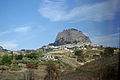
The archaeological site of Polizzello or mountain of Polizzello was a site inhabited probably from the eleventh to the sixth century BC
The name apparently derives from the tyrant Polyzelus.
According to another thesis the name derives from the Greek πολις Ειθηλος (Polizzello), although so far there is no archaeological evidence that may indicate the presence of a Greek settlement in the area.
The site is located on a hill at 877 m above sea level and is near Mussomeli in the Province of Caltanissetta.
The site is great for a human settlement for its easily defensible position and for the presence of water sources. It consists of two plateaus of which the upper smallest one is home of Acropolis and place of the first protohistoric and archaic settlement, moreover; the site has an east–west orientation with a single access from east.
Historically, the site had three significant phases:
Early Bronze Age (19th–16th centuries BC), of which remain some chamber tombs of Castelluccio period and a circular hut with ornaments placed on the eastern side of the mountain.
11th–9th centuries BC with the creation of an Acropolis placed on top of the hill.
Text from Wikipedia, the free encyclopedia, under CC BY-SA 4.0. Full article: «Polizzello archaeological site».
Distances are as the crow flies, not walking or driving.


Polizzello archaeological site is in Mussomeli, in the province of Caltanissetta (Sicily), Italy. GPS coordinates: 37.60760, 13.82613.
Nearby you’ll find: Castle of Mussomeli (5.9 km away), Mytistraton (8 km away), Sutera (12.2 km away).
Text. Wikipedia, the free encyclopedia (CC BY-SA 4.0).
Data. Wikidata (CC0); opening hours and contacts OpenStreetMap (ODbL).
Photos. Wikimedia Commons, author and licence on every image.
Updated 28 October 2026. All sources and licences