

- UNESCO
Photo: Public domain · Wikimedia Commons
Segesta (Ancient Greek: Ἔγεστα, Egesta, or Σέγεστα, Ségesta, or Αἴγεστα, Aígesta; Sicilian: Siggesta) was one of the major cities of the Elymians, one of the three indigenous peoples of Sicily. The other major cities of the Elymians were Eryx and Entella.
Segesta is located in the northwestern part of Sicily in Italy, near the modern commune of Calatafimi-Segesta in the province of Trapani. The hellenization of Segesta happened very early and had a profound effect on its people.
The sixth century geographer Stephanus of Byzantium writes that the city also was called Akeste (Ἀκέστη), named after a certain Akestes (Ἀκέστης). Researchers state that the form Ἀκέστη is an otherwise unattested analogical form to the Latin Acesta. The city is usually called Ἔγεστα or Αἴγεστα.
The origin and foundation of Segesta are extremely obscure. The tradition current among the Greeks and adopted in the fifth century BC by Thucydides, ascribed its foundation to a band of Trojan settlers, fugitives from the destruction of their city; and this tradition was readily welcomed by the Romans, who in consequence claimed a kindred origin with the Segestans. Thucydides seems to have considered the Elymians (Latin: Elymi), a barbarian tribe in the neighborhood of Eryx and Segesta, as descended from the Trojans in question; but another account represents the Elymi as a distinct people, already existing in this part of Sicily when the Trojans arrived there and founded the two cities. A different story seems also to have been current, according to which Segesta owed its origin to a band of Phocians, who had been among the followers of Philoctetes; and, as usual, later writers sought to reconcile the two accounts.
Another version of the Trojan story related during the first century AD in Virgil's Aeneid, which would seem to have been adopted by the inhabitants themselves, ascribed the foundation of the city jointly by the territorial king Egestus or Aegestus (the Acestes of Virgil), who was said to be the offspring of a Dardanian woman named Segesta and fathered by the river god Crinisus, and by those of Aeneas' folk who wished to remain behind with Acestes to found the city of Acesta. We also are told by another first century geographer, Strabo, that the names of Simois and Scamander were given by the Trojan colonists to two small streams that flowed beneath the town, and the latter name is mentioned by the first century historian, Diodorus Siculus, as one still in use at a much later period.
A disproved belief that the name of the city was originally Acesta or Egesta and changed to Segesta by the Romans to avoid its ill-omened meaning in Latin (egestās means "poverty" or "lack") is corrected by coins that provide evidence that considerably before the time of Thucydides it was called Segesta by the inhabitants and that this name seems to have been softened by the Greeks of Magna Graecia into Egesta. …
The ruins of the city are located on the top of Monte Bàrbaro at 305 m above sea level. The city was protected by steep slopes on several sides and by walls on the more gentle slope towards the temple.
The hilltop offers a view over the valley towards the Gulf of Castellamare. The city controlled several major roads between the coast to the north and the hinterland. Very little is known about the city plan. Aerial photography indicates a regular city plan, built in part on terraces to overcome the natural sloping terrain. The current remains might be from the reconstruction after the destruction of the city by Agathocles.
Current archaeological work indicates that the site was reoccupied by a Muslim community in the Norman period. Excavations have unearthed a Muslim necropolis and a mosque from the 12th century next to a Norman castle. Evidence suggests that the mosque was destroyed after the arrival of a new Christian overlord at the beginning of the 13th century. The city appears to have been finally abandoned by the second half of the 13th century.
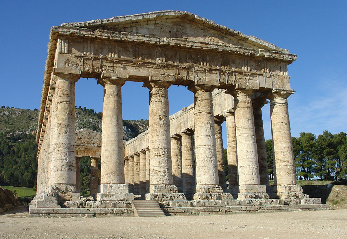
On a hill just outside the site of the ancient city of Segesta lies an unusually well-preserved Doric temple. Some think it to have been built in the 420s BC by an Athenian architect, despite the city not having any Greek population. The prevailing view is that it was built by the indigenous Elymians. The temple has six by fourteen columns on a base measuring 21 by 56 metres, on a platform three steps high. Several elements suggest that the temple was never finished. The columns have not been fluted as they normally would have been in a Doric temple, and there are still bosses present in the blocks of the base (used for lifting the blocks into place but then normally removed). The temple also lacks a cella, any ornamentation, altar or deity dedication, and was never roofed over. The temple was never completed due to the war between Segesta and Selinunte. It managed to escape destruction by the Carthaginians in the late 5th century BC.
Text from Wikipedia, the free encyclopedia, under CC BY-SA 4.0. Full article: «Segesta».
Distances are as the crow flies, not walking or driving.


Segesta is in Calatafimi-Segesta, in the province of Trapani (Sicily), Italy. Address: Contrada Barbaro 5, 91013 Calatafimi-segesta. GPS coordinates: 37.94143, 12.83249.
Nearby you’ll find: Doric temple of Segesta (100 m away), Greek Theatre of Segesta (1 km away), Castello Eufemio (3.7 km away).
Text. Wikipedia, the free encyclopedia (CC BY-SA 4.0).
Data. Wikidata (CC0); opening hours and contacts OpenStreetMap (ODbL).
Photos. Wikimedia Commons, author and licence on every image.
Updated 28 October 2026. All sources and licences