



- UNESCO
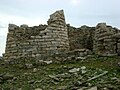
Photo: Daniela Serra (Cagliari), CC BY-SA 3.0 · Wikimedia Commons
Archaeological site
Archaeological site in Italy
The Nuragic sanctuary of Santa Vittoria is an archaeological site located in the municipality of Serri, Sardinia, in Italy. The name refers to the Romanesque style church built over a place of Roman worship which rises at the westernmost tip of the site. The Santa Vittoria site was frequented starting from the first phase of the Nuragic civilization corresponding to Middle Bronze Age (1600-1300 BC). Subsequently, from the late Bronze Age to the early Iron Age (1100-900 / 800 BC), the place became one of the most important expressions of the Nuragic civilization and today it constitutes the most important Nuragic complex so far excavated.
The presence of a significant layer of ash found in the excavations has led to the conclusion that in Roman times, the site suffered a serious fire that devastated it completely.
The various excavation campaigns, started in 1909 by Antonio Taramelli, extracted objects such as stylized nuraghes, bronze and stone bull protomes, votive weapons, fragments of lamps, and numerous ex-voto, mostly in bronze, consisting of anthropomorphic and zoomorphic figurines and models of everyday objects.
The excavated area of the site has an extension of about 30,000 square metres (7.4 acres) but, as a whole, its original extension was 200,000 square metres (49 acres).
the tholos nuraghe, which incorporated the pre-existing protonuraghe, dating back to the Recent Bronze Age (1300-1100 BC);
the well temple, the nearby "hypetral" (open air – without roof) temple, the sacred way; the two in antis temples, the first known as priest's hut and the other, located further north, known as chief's hut. All of them were built in the period between the final Bronze Age and the first Iron Age (1100 - 900/800 BC);
the small church of Santa Maria della Vittoria built in the Byzantine era.
the enclosure of the feasts (also enclosure of the meetings), coeval of the well temple, along whose inner perimeter are placed, facing the large internal area: a long porch, huts with benches and seats, the founders' hut, the market, three huts including that of the double-headed ax, the kitchen;
a group of buildings consisting of houses, including that of the double baetylus - from the name of the sacred artefact found there - belonging to the period between the final Bronze Age and the early Iron Age (1100 - 900/800 BC);
a fourth group of buildings, on the east side of the site, where the enclosure of tortures and the curia are located. They were built in the period between the final Bronze Age and the early Iron Age (1100 - 900/800 BC)
The buildings are sometimes referred to be different names in different archaeological publications. For example, the enclosure of the feasts is also called the 'enclosure of the meetings', and the curia is sometimes named 'hut of the meetings'. Therefore, to improve clarity, the number that was attributed to the buildings by Taramelli in his general representation of the site is used as a general reference. However, when his plan was published in 1931, due to the graphic format of the volume, a large empty portion of land between the enclosure of the feasts and the group of houses and the curia was eliminated. All plans published subsequently, including those shown to visitors, maintain the same error. Only the aerial photographs give its real size.
(Taramelli numbers 2 - 4)
Near the western edge of the site, close the church of Santa Vittoria, the remains of a nuragic tower are found. It was built with rows of basalt blocks and has an external diameter of about 7.5 metres (25 ft) with slits splayed inwards and dates to the recent Bronze Age (1300-1220 BC).
From the tower starts a corridor about 8 metres (26 ft) long and 1 metre (3.3 ft) high supported by two wings of jutting out basalt blocks that originally formed a covering. The corridor reaches the wall at the edge of the plateau.
The megalithic structures between the corridor and the wall have been attributed to a protonuraghe dated to the Middle Bronze Age (1500 - 1330 BC).
On the ruins of this complex, a staircase of white limestone slabs was erected in Roman times which led to a small building, rectangular on the outside and almost circular inside, built in masonry with cocciopesto (Opus signinum) floor and tiled roof. Taramelli identified this building as the "aedes victoriae" or shrine of victory in memory of the Roman victory over the Sardinians and the destruction of the nuragic sanctuary. According to Taramelli this title gave the name to the church and then to the entire site.
(Taramelli number 13)
The well temple is the most important place in the whole sanctuary, such as to be recognized first and immediately subject to excavation.
The well temple was erected with isodomic masonry, with regular rows of well-squared blocks of basalt and limestone that give a two-tone effect. It impressed Taramelli for its construction without mortar. It has a residual height of about 3 metres (9.8 ft) below ground level and about 1.2 metres (3.9 ft) above it and consists of a circular well of about 2 metres (6.6 ft) in diameter. The sacred water collects in a basin with a rounded bottom at the base of the well through special holes in the wall that allow rainwater to filter through. The wall is very regular and is made of twenty rows of black basalt stones, very well worked in the visible part and wedge-shaped in the part in contact with the rock well. …
The site of Santa Vittoria was unknown until the beginning of the 20th century when the local doctor, who was a friend of the archaeologist Antonio Taramelli, then director of the Cagliari museum and of Sardinia's antiquity excavations, pointed out to him the Santa Vittoria site as worthy of interest.
The first excavation was personally conducted in 1909-1910 by Taramelli with the collaboration of Filippo Nissardi, an archaeologist from Cagliari, and the inspector of the prehistoric and ethnographic museum of Rome Raffaele Pettazzoni. The first highlighted buildings were the city walls, the well temple and the meeting hut (or curia).
The campaign of 1919 - 1921 recovered significant votive bronzes.
In the campaign carried out between 1922 and 1929 discovered the in antis temple chief's hut and the enclosure of feasts fence, along with other buildings.
Taramelli began publications on Santa Vittoria in 1914 and concluded them in 1931 with two volumes published by the Accademia dei Lincei.
It was during his first excavation campaign that Taramelli identified the Roman building which he named aedes victoriae (shrine of Victory) after which the church took its name and the site after it. This edifice was however demolished by Taramelli, as documented by him in 1931, to complete the exposure of the underlying nuragic layer.
In 1963 Ercole Contu of the Superintendence for Antiquities of Sassari and Nuoro restored the enclosure of the feasts and the hypetral temple. This excavation recovered important nuragic ceramic artefacts and the remains of meals eaten in the enclosure, such as wild boar bones.
Recent excavations were conducted in 1990, 2002 and 2006 by the Superintendence for antiquities, in 2011 and in 2015 by Maria Gabriella Puddu.
From 1 October 2019 the Superintendence of archeology, fine arts and landscape of Cagliari has started a new excavation campaign with consolidation and restoration works. …
Text from Wikipedia, the free encyclopedia, under CC BY-SA 4.0. Full article: «Nuragic sanctuary of Santa Vittoria».
Distances are as the crow flies, not walking or driving.


Nuragic sanctuary of Santa Vittoria is in Serri, in the province of Sud Sardegna (Sardinia), Italy. Address: Strada Comunale Localita' Santa Vittoria, Serri. GPS coordinates: 39.71313, 9.10689.
According to OpenStreetMap the opening hours are: Every day: 9:00–sunset. Always check the official website before your visit.
Nearby you’ll find: Nuraghe Is Paras (3.9 km away), Polo museale casa Zapata (9.2 km away), Su Nuraxi di Barumini (9.2 km away).
Text. Wikipedia, the free encyclopedia (CC BY-SA 4.0).
Data. Wikidata (CC0); opening hours and contacts OpenStreetMap (ODbL).
Photos. Wikimedia Commons, author and licence on every image.
Updated 28 October 2026. All sources and licences