


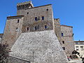

- Most beautiful villages
Photo: Mattana, Public domain · Wikimedia Commons
Santa Fiora is a comune (municipality) in the province of Grosseto, in the Italian region of Tuscany, located about 40 km (25 mi) east of Grosseto. Santa Fiora borders the following municipalities: Abbadia San Salvatore, Arcidosso, Castel del Piano, Castell'Azzara, Piancastagnaio, Roccalbegna, and Semproniano. It is one of I Borghi più belli d'Italia ("The most beautiful villages of Italy").
Santa Fiora is mentioned for the first time in 890 AD, in a document listing properties of the Abbey of San Salvatore, Sforza Cesarini Archive Rome. By the eleventh century the lords of Santa Fiore were the Aldobrandeschi who, in 1082, started the construction of a castle here (Castello S. Flore) and walled the borgo. The power of the abbey passed by degrees to the Aldobrandeschi conti di San Fire, and in turn to the hegemony in Lower Tuscany of the commune of Siena, which had a strong influence on Santa Fiora by the mid fourteenth century, a future already foreseen by Dante: "e vedrai Santafior com' è oscura" – "and you shall see how obscure is Santa Fiore" (Purgatorio, canto VI, 111). In 1439, with the marriage of Cecilia Aldobrandeschi and Bosio Sforza, the castello and its town passed to the Sforza.
The Sforza of Santa Fiora reached their highest point of power with count Guido Sforza di Santa Fiora, who managed to establish himself as a relative of Pope Paul III Farnese, thereby gaining prestigious political positions for his relatives. Later the family became the Sforza Cesarini, who are still well represented and living in their Roman Palazzo Sforza Cesarini. The sovereign rights of the small state of Santa Fiora were sold to the Grand Duchy of Tuscany under Leopold II though all feudal rights remained to the family.
The comune was of importance for its mineral wealth in Monte Amiata of cinnabar, from which mercury is derived.
In the Middle Ages and during the modern era Santa Fiora was the capital of an independent state, the County of Santa Fiora.
Text from Wikipedia, the free encyclopedia, under CC BY-SA 4.0. Full article: «Santa Fiora».
Address
Ufficio Turistico, Piazza Giuseppe Garibaldi, 39 58037 Santa Fiora GR
Our data shows no stations, stops or car parks nearby. Check how to get there before you set out.


Santa Fiora is in Santa Fiora, in the province of Grosseto (Tuscany), Italy. Address: Ufficio Turistico, Piazza Giuseppe Garibaldi, 39 58037 Santa Fiora GR. GPS coordinates: 42.83194, 11.58528.
Nearby you’ll find: Palazzo Sforza Cesarini (0 m away), Museo delle miniere di mercurio del Monte Amiata (100 m away), Santissima Trinità (3.4 km away).
Text. Wikipedia, the free encyclopedia (CC BY-SA 4.0).
Data. Wikidata (CC0); opening hours and contacts OpenStreetMap (ODbL).
Photos. Wikimedia Commons, author and licence on every image.
Updated 28 October 2026. All sources and licences