



Photo: Giorgiomugnaini, Public domain · Wikimedia Commons
Archaeological site
Populonia
Frazione of Italy
At a glance
- Type
- Archaeological site
- Elevation
- 170 m above sea level
- Coordinates
- 42°59′22″ N, 10°29′29″ E
History and description
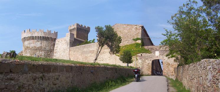
Populonia or Populonia Alta (Etruscan: Pupluna, Pufluna or Fufluna) is a small village and frazione of the comune of Piombino (Tuscany) situated on the west coast of Italy.
Populonia is noteworthy for its Etruscan remains which include one of the main necropoles in Italy, extending over a large surrounding area much of which is now within the Baratti and Populonia Archeological Park.
Its history is closely linked to the exploitation of the mineral resources of the Metalliferous Hills and the nearby island of Elba which made it the iron-working centre of Etruria.
The Archaeological Museum of Populonia in Piombino contains finds from the ancient territory of Populonia.
Description
The hamlet of modern Populonia is located within a small part of the walled acropolis of the ancient city which covered the entire north end of Monte Massoncello promontory and extended down to the Bay of Baratti, on the shore of which was its port.
The city's wealth was derived from smelting several metal ores from the inland Colline Metallifere (the "metal-bearing hills") and later from iron ore mined on nearby Elba. Over the thousand years of the city's life, enormous quantities of waste slag from smelters was deposited and eventually covered the slopes and shore of the bay of Baratti burying abandoned buildings and cemeteries up to 10m deep until the ore ran out, when the city was abandoned and knowledge of most of the site was eventually lost.
Starting from the 1920s the still iron-rich slag was removed and reworked for its valuable content which led to rediscovery of the Etruscan necropoleis and other buildings, attracting the attention of the archaeologists. Soon it was realised that not only Populonia but the entire Val di Cornia (Valley of the nearby Cornia River) had been densely populated in Etruscan times. They uncovered the Villanovan, Orientalising, and archaic necropolises of Porcareccia, San Cerbone, Casone, and Poggio and Piano delle Granate. The work was hasty and the oldest tombs sought, and many late Classical and Hellenistic-Roman burials in the surface layers were destroyed.
Since 1998 the site has been the subject of a coordinated programme of excavations, the results of which are published in the Materiali per Populonia series. Research continues, most recently with the 2023-2025 excavations on the acropolis.
In recognition of the area's importance to archaeology, a system of parks was created, the Parchi della Val di Cornia, with a key park being the Parco archeologico di Baratti e Populonia, the "Baratti and Populonia Archeological Park", which covers the hill with the acropolis and the entire Bay of Baratti and its shores. Another is the Archaeological Area of Poggio del Molino.
History
A number of stories about the foundation of Populonia promulgated by the classical authors writing several hundred years later have been found to have no basis in archaeology. Maurus Servius Honoratus in his commentary on Vergil's Aeneid says that Populonia was founded later than the other cities by Corsicans, who were driven out by Etruscans from Volterra or by Volterraneans without the Corsican interlude. However, Populonia is Villanovan in provenance and no material remains of any Corsicans have been found or excavated, the tombs are unlike those of Volterra, and Populonia was by far the major settlement.
Strabo claimed that Populonia was the only Etruscan coastal city; the others were removed from the coast by several miles. He may not have known that Pisa had been a major Etruscan city before it was Roman. Spina also had been placed at the edge of the Po River and has been termed the Etruscan Venice. Also the minor settlements of Pyrgi and Gravisca were early Etruscan ports. By Strabo's time, the Romans had seized the entire coastline and had ejected the Etruscans from it.
The summit of Poggio del Telegrafo on the acropolis was densely inhabited from the start of the Iron Age, as shown by excavations, with huts of different structure and size of the same date as the Villanovan cemeteries, about 900 BC. The site combined two advantages: as a coastal promontory it was easy to defend and embraced views of the coast and Elba. The inhabitants moved here after numerous nearby coastal villages of the final Bronze Age were abandoned. …
The city
The walls of the acropolis on the tops of the Telegrafo and Castello hills were built in sandstone in the first quarter of the 3rd century BC, and had a perimeter of 2.4 km enclosing an area of about 20 hectares; in adddition the so-called Low Walls protected the northern area of the promontory between the gulf of Baratti and Cala San Quirico and a third wall was along the watershed, called "bretella". The Low walls had at least three gates and were discovered from 1926 and largely destroyed by the removal of the ferrous waste; they were dated to the end of the 4th century BC. The walls of the acropolis also functioned as terracing, containing the erosion of the land and creating flat urban spaces.
In its monumental phase between the end of the 3rd and the first decades of the 1st century BC, the acropolis was organised around two streets paved in sandstone and with sidewalks on benches, under which rainwater channels led to cisterns, including a large double-chamber public reservoir on the slopes of Poggio del Telegrafo. The three temples overlooked the square of the saddle; in a scenographic position on the slope stood the complex of the Logge, a public building on several terraces whose function is still debated, perhaps a sanctuary dedicated to Venus; along the streets there were houses and shops, in addition to the large domus.
The necropoleis form one of the most important funerary complexes of the Etruscan civilisation. They are distributed in the gulf of Baratti and on the hills that surround it and include nuclei from the early Iron Age to the Hellenistic age. Unlike other Etruscan cities, the burial grounds do not surround the inhabited area but occupy spaces within.
Most of the contents of the tombs were robbed in antiquity but some which were soon buried deeply in slag retained valuable objects which have been recovered. The grave goods are conserved mainly in the museums of Piombino and Florence, where pieces recovered from the antiques market also arrived between the nineteenth and twentieth centuries; a collection is also in the museum of the Gasparri private collection in Populonia Alta. …
Text from Wikipedia, the free encyclopedia, under CC BY-SA 4.0. Full article: «Populonia».
Photos
Getting there
PopuloniaTrain, nearest
4.1 km as the crow flies
Populonia
Molo 87.9 km
Aeroporto di Marina di Campo32.6 km
Distances are as the crow flies, not walking or driving.
Loading map…
Nearby
See on the mapMore archaeological sites in Tuscany


- Free 1st Sunday
Frequently asked questions
Where is Populonia?
Populonia is in Piombino, in the province of Livorno (Tuscany), Italy. GPS coordinates: 42.98944, 10.49139.
What else is there to see near Populonia?
Nearby you’ll find: Museo Gasparri (0 m away), Stronghold of Populonia (0 m away), Baratti lighthouse (700 m away).
Sources and licences
Text. Wikipedia, the free encyclopedia (CC BY-SA 4.0).
Data. Wikidata (CC0); opening hours and contacts OpenStreetMap (ODbL).
Photos. Wikimedia Commons, author and licence on every image.
Credits for the 9 photos
- Populonia1 — Giorgiomugnaini, Public domain
- Gulf of Baratti from Populonia Alta, Panorama — Manuel Wieser, CC BY-SA 3.0
- Il castello di Populonia - La Piazza — PROPOLI87, CC BY-SA 4.0
- ISS064-E-51251 - View of Italy - Tyrrhenian Sea - San Vincenzo, Populonia coast - Golfo di Baratti - Populonia - Punta delle Pianacce - Poggio San Leonardo (cropped) — Earth Science and Remote Sensing Unit, Lyndon B. Johnson Space Center, Public domain
- La Piazza del Castello - Golfo di Baratti da Populonia — PROPOLI87, CC BY-SA 4.0
- La piazza di Populonia — PROPOLI87, CC BY-SA 4.0
- Piombino - LI - Mura del borgo di Populonia — Stefano Benucci, CC BY-SA 4.0
- Populonia - an house — Jalo, Public domain
- Populonia - building — Przemek P, CC BY-SA 3.0
Updated 28 October 2026. All sources and licences