


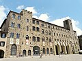


Photo: Geobia, CC BY-SA 3.0 · Wikimedia Commons
Historic villa / palace
Palazzo Guarnacci
Building in Volterra, Italy
At a glance
- Protection
- Italian national heritage
- Coordinates
- 43°24′08″ N, 10°51′34″ E
- Address
- Via di Sotto, 2
Photos
Getting there
Volterra-Saline-PomaranceTrain, nearest
6.2 km as the crow flies
Palazzo GuarnacciVia di Sotto, 2
Distances are as the crow flies, not walking or driving.
Loading map…
Nearby
See on the mapDo you know this place?
We are missing the opening hours and a description. The data comes from open projects: if you add it there, it appears here at the next update.
More historic villas and palaces in Tuscany

- Free 1st Sunday

- UNESCO
- Free 1st Sunday

- UNESCO
- Free 1st Sunday

- Free 1st Sunday

Frequently asked questions
Where is Palazzo Guarnacci?
Palazzo Guarnacci is in Volterra, in the province of Pisa (Tuscany), Italy. Address: Via di Sotto, 2. GPS coordinates: 43.40236, 10.85942.
What else is there to see near Palazzo Guarnacci?
Nearby you’ll find: Pinacoteca e museo civico di Volterra (0 m away), Teatro Persio Flacco (0 m away), Palazzo Pretorio (100 m away).
Sources and licences
Data. Wikidata (CC0); opening hours and contacts OpenStreetMap (ODbL).
Photos. Wikimedia Commons, author and licence on every image.
Credits for the 2 photos
- 902VolterraMuseoEtrusco — Geobia, CC BY-SA 3.0
- Il nuovo Museo Etrusco di Volterra. Bassorilievi, vasi cinerari e vasi fittili (xilografia) — Barberis, Public domain
Updated 28 October 2026. All sources and licences