






Photo: Physiker52, CC BY-SA 4.0 · Wikimedia Commons
At a glance
- Type
- Fortress / Tower
- Period
- Modern era, 1914
- Protection
- Italian national heritage
- Coordinates
- 45°53′19″ N, 11°23′17″ E
- Address
- 36010 Rotzo (VI)
History and description
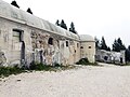
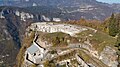
Fort Campolongo is an Italian fortification built just before World War I. The fort is built into the sheer cliffs overlooking the Asiago Valley at an altitude of 1,720m (5700ft). The fort was built between 1912 and 1914, and was thus one of the newest fortifications in the Asiago sector of the Agna-Assa Barrier. Campolongo was relatively weak due to being constructed out of unreinforced concrete, which would later prove fatal. Campolongo was built at nearly the maximum range of the Austro-Hungarian guns in the Lavarone-Folgaria Group on the other side of the border.
World War I
In the closing days of May 1915, Campolongo fired at Fort Lusern across the border, much to no avail. From nearby Lusern, the Austro-Hungarians fired their monster 305mm Mörsers back, which on June 12, knocked out 1 gun and killed the fort’s commander and 44 men. The remaining guns were removed and Campolongo was of no strategic value anymore. On May 15, 1916, It was bombarded by heavy guns which marked the opening of the Austro-Hungarian Spring Offensive, also called the Battle of Asiago. On May 22, Campolongo, alongside the nearby Forte Verena which fired the first shot of the war between Italy and Austria-Hungary, were occupied by the Austrians. The rest of the war the fort was occupied by the Austrians, but they made no intention to arm it and Campolongo never fired a shot again.
Text from Wikipedia, the free encyclopedia, under CC BY-SA 4.0. Full article: «Forte Campolongo».
Timeline
- 1914Built
Events and people from Wikidata (CC0).
Photos
Getting there
Levico TermeTrain, nearest
14.5 km as the crow flies
Forte Campolongo36010 Rotzo (VI)
Distances are as the crow flies, not walking or driving.
Loading map…
Nearby
See on the mapMore fortresses and towers in Veneto


Frequently asked questions
Where is Forte Campolongo?
Forte Campolongo is in Rotzo, in the province of Vicenza (Veneto), Italy. Address: 36010 Rotzo (VI). GPS coordinates: 45.88871, 11.38811.
How old is Forte Campolongo?
Wikidata dates it to 1914.
What else is there to see near Forte Campolongo?
Nearby you’ll find: Museo archeologico dell'Altopiano dei Sette Comuni (3.5 km away), Bostel (3.8 km away), Forte Monte Verena (5 km away).
Sources and licences
Text. Wikipedia, the free encyclopedia (CC BY-SA 4.0).
Data. Wikidata (CC0); opening hours and contacts OpenStreetMap (ODbL).
Photos. Wikimedia Commons, author and licence on every image.
Credits for the 9 photos
- Forte Compolongo 1 — Physiker52, CC BY-SA 4.0
- Forte Campolongo abc1 — Patafisik & Elena Tartaglione, CC BY-SA 4.0
- Forte Campolongo abc13 guardia — Patafisik & Elena Tartaglione, CC BY-SA 4.0
- Forte Campolongo abc37 calotte delle cannoniere — Patafisik & Elena Tartaglione, CC BY-SA 4.0
- Forte Campolongo abc38 cannoniera senza calotta — Patafisik & Elena Tartaglione, CC BY-SA 4.0
- Forte Campolongo abc39 trincea verso il fossato di gola — Patafisik & Elena Tartaglione, CC BY-SA 4.0
- Forte Campolongo abc40 trincea verso il fossato di gola — Patafisik & Elena Tartaglione, CC BY-SA 4.0
- Forte Campolongo abc46 supporti per bombe in una cannoniera — Patafisik & Elena Tartaglione, CC BY-SA 4.0
- Asiago Campolongo 2 22-08-04 10.07.14 — Antonio Cunico, CC BY-SA 4.0
Updated 28 October 2026. All sources and licences