


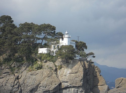
Photo: Andrea Albini, CC BY-SA 3.0 · Wikimedia Commons
Lighthouse, 1883
Capo di Vado Lighthouse
Lighthouse in Bergeggi, Italy
At a glance
- Type
- Lighthouse
- Period
- Modern era, 1883
- Protection
- Italian national heritage
- Coordinates
- 44°15′29″ N, 8°27′09″ E
- Address
- Via Aurelia, 2, Bergeggi (SV)
History and description
Capo di Vado Lighthouse (Italian: Faro di Capo di Vado) is an active lighthouse located on the prominent Capo di Vado, 1.5 kilometres (0.93 mi) south of Vado Ligure, Liguria on the Ligurian Sea.
Description
The lighthouse was built in 1883 and consists of a white masonry octagonal prism tower, 34 feet (10 m) high, with balcony and lantern attached to the seaward side of a 3-storey white keeper's house The lantern is painted in white, the dome in grey metallic, and is positioned at 43 metres (141 ft) above sea level and emits four white flashes in a 15 seconds period visible up to a distance of 14 nautical miles (26 km; 16 mi). The lighthouse is completely automated and operated by the Marina Militare with the identification code number 1514 E.F.
Text from Wikipedia, the free encyclopedia, under CC BY-SA 4.0. Full article: «Capo di Vado Lighthouse».
Timeline
- 1883Built
Events and people from Wikidata (CC0).
Getting there
Quiliano-VadoTrain, nearest
2.8 km as the crow flies
Capo di Vado LighthouseVia Aurelia, 2, Bergeggi (SV)
Bastia-Savona600 m
Aeroporto Internazionale di Genova - Cristoforo Colombo35.5 km
Distances are as the crow flies, not walking or driving.
Loading map…
Nearby
See on the mapMore lighthouses in Liguria



Frequently asked questions
Where is Capo di Vado Lighthouse?
Capo di Vado Lighthouse is in Bergeggi, in the province of Savona (Liguria), Italy. Address: Via Aurelia, 2, Bergeggi (SV). GPS coordinates: 44.25806, 8.45252.
How old is Capo di Vado Lighthouse?
Wikidata dates it to 1883.
What else is there to see near Capo di Vado Lighthouse?
Nearby you’ll find: Forte San Giacomo (400 m away), Forti San Lorenzo e Santo Stefano (400 m away), Grotta di Bergeggi (1.8 km away).
Sources and licences
Text. Wikipedia, the free encyclopedia (CC BY-SA 4.0).
Data. Wikidata (CC0); opening hours and contacts OpenStreetMap (ODbL).
Photos. Wikimedia Commons, author and licence on every image.
Credits for the 1 photos
- Bergeggi - SS1 - Il Faro - Via Aurelia - panoramio (1) — Andrea Albini, CC BY-SA 3.0
Updated 28 October 2026. All sources and licences