




- Most beautiful villages
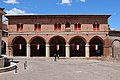
Photo: Foresa85, CC BY-SA 4.0 · Wikimedia Commons
Esanatoglia is a town and comune in the Marche, Italy. It is one of I Borghi più belli d'Italia ("The most beautiful villages of Italy").
According to the legend, Esus, the Celtic God of war, would be the origin of the name of the Esino river, on whose shores a town, Aesa, is presumed to have been founded in Roman times.
The current name Esanatoglia was given in 1862, from a combination between Aesa and Anatolia, replacing the medieval Santa Anatolia, which in turn was derived from Saint Anatolia, a 3rd-century Christian martyr. The first known document referring to Santa Anatolia dates from 1015, concerning the foundation of the monastery of Sant’Angelo by Conte Atto and his wife Berta. The monastery became soon the most important religious establishment in the area.
The city was ruled by the Malcavalca until 1211, when they were succeeded the Ottoni di Matelica. Three years later, and for three hundred years, the da Varano family hold the city. Under the da Varano Santa Anatolia maintained a certain autonomy: the first collection of statutory norms dates from 1324. The citadel remained immune from wars and pillages until 1443, when it was conquered by Francesco I Sforza. The monastery of Sant'Angelo and its library did not escape the devastation.
Eremo di San Cataldo; formerly part of a hermitage, now a guard tower of medieval origin, located at the top of the mountain facing the city.
Eremo di San Pietro di Esanatoglia; formerly a hermitage atop a steep mountain side.
Fountain of San Martino (possibly from the 12th century). In 1534 it was re-built by order of Cardinal Alessandro Farnese
Text from Wikipedia, the free encyclopedia, under CC BY-SA 4.0. Full article: «Esanatoglia».
Distances are as the crow flies, not walking or driving.


Esanatoglia is in Esanatoglia, in the province of Macerata (Marche), Italy. GPS coordinates: 43.25135, 12.94589.
Nearby you’ll find: Ponte di Pioraco (8.6 km away), Paper and Watermark Museum Fabriano (9.8 km away), Archivio storico delle Cartiere Miliani Fabriano (9.9 km away).
Text. Wikipedia, the free encyclopedia (CC BY-SA 4.0).
Data. Wikidata (CC0); opening hours and contacts OpenStreetMap (ODbL).
Photos. Wikimedia Commons, author and licence on every image.
Updated 28 October 2026. All sources and licences