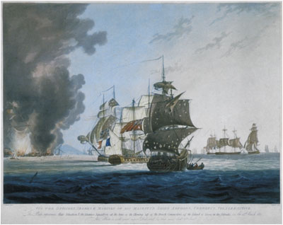




Photo: Henri Merke / After George Webster, Public domain · Wikimedia Commons
Archaeological site
French frigate Danaé
1807 Consolante-class frigate
Muggia (TS), Friuli Venezia Giulia
At a glance
- Type
- Archaeological site
- Coordinates
- 45°37′01″ N, 13°45′60″ E
About
Danaé was a 44-gun Consolante-class frigate of the French Navy. On 12 March 1811, she was part of Bernard Dubourdieu's squadron sailing to raid the British commerce raider base of the island of Lissa. The squadron encountered William Hoste's frigate squadron, leading to the Battle of Lissa. Danaé was damaged by HMS Volage and had to retreat to Lesina for repairs. In the night of 4 September 1812, she exploded in the harbour of Trieste.
Text from Wikipedia, the free encyclopedia, under CC BY-SA 4.0. Full article: «French frigate Danaé».
Timeline
- 1807Ship launching
- 1812Shipwrecking
Events and people from Wikidata (CC0).
Getting there
Trieste CentraleTrain, nearest
4.6 km as the crow flies
French frigate Danaé
Muggia - Diga Foranea1.1 km
Letališče Portorož / Aeroporto Portorose19.9 km
Distances are as the crow flies, not walking or driving.
Loading map…
Nearby
See on the mapMore archaeological sites in Friuli Venezia Giulia


Frequently asked questions
Where is French frigate Danaé?
French frigate Danaé is in Muggia, in the province of Trieste (Friuli Venezia Giulia), Italy. GPS coordinates: 45.61682, 13.76664.
What else is there to see near French frigate Danaé?
Nearby you’ll find: Muggia Castle (1.4 km away), Museo d'Arte Moderna "Ugo Carà" (1.5 km away), Risiera di San Sabba (1.8 km away).
Sources and licences
Text. Wikipedia, the free encyclopedia (CC BY-SA 4.0).
Data. Wikidata (CC0); opening hours and contacts OpenStreetMap (ODbL).
Photos. Wikimedia Commons, author and licence on every image.
Credits for the 1 photos
- BattleofLissa1811(2) — Henri Merke / After George Webster, Public domain
Updated 28 October 2026. All sources and licences