


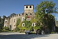


Photo: S.Roberto73, CC BY-SA 4.0 · Wikimedia Commons
At a glance
- Type
- Castle
- Period
- Middle Ages, 1176
- Protection
- Italian national heritage
- Coordinates
- 45°42′07″ N, 7°12′40″ E
- Address
- Loc. Châtel-Argent - 11018 Villeneuve (AO)
History and description
Châtel-Argent was an Italian medieval castle in the Alpine town of Villeneuve. It is now a ruin. As with many other castles in the region, Châtel-Argent overlooks the Dora Baltea (French: Doire baltée) River which runs through the Aosta Valley.
History
Originally the home of the Salassi people, settlements have existed on this site since prehistoric times and through the Roman Era. There is a chapel dedicated to Saint Columba of Sens which was built sometime between 1050 and 1070. The castle first appears in a document in 1176 as "Castrum Argenteum". The castle was improved around 1275 under the direction of Count Peter II's architect James St. George (French: Maître Jacques de Saint-Georges) and castle grew to the configuration we see today. This castle had always been owned by the counts and the dukes of Savoy.
Description
The ruins can be accessed from Villeneuve by walking a staircase carved into the rock of the valley wall. The castle is located in the town of Villeneuve in the Aosta Valley region, at about 10 km west of the city of Aosta. The most prominent feature left in the ruins is its watchtower keep measuring just under 10 meters in diameter which overlooks the town below. The ruins themselves cover about 6,300 square meters. When the castle was whole, it was estimated to be able to hold 700 people in times of danger.
Text from Wikipedia, the free encyclopedia, under CC BY-SA 4.0. Full article: «Châtel-Argent».
Timeline
- 1176Built
Events and people from Wikidata (CC0).
Photos
Getting there
ArvierTrain, nearest
3.5 km as the crow flies
Châtel-ArgentLoc. Châtel-Argent - 11018 Villeneuve (AO)
Aeroporto regionale della Valle d'Aosta / Aéroport régional de la Vallée d'Aoste12.9 km
Distances are as the crow flies, not walking or driving.
Loading map…
Nearby
See on the mapMore castles in Aosta Valley


Frequently asked questions
Where is Châtel-Argent?
Châtel-Argent is in Villeneuve (Aosta Valley), Italy. Address: Loc. Châtel-Argent - 11018 Villeneuve (AO). GPS coordinates: 45.70207, 7.21123.
How old is Châtel-Argent?
Wikidata dates it to 1176.
What else is there to see near Châtel-Argent?
Nearby you’ll find: Tour Colin (500 m away), Sarriod de la Tour Castle (1.2 km away), Regional Natural Science Museum (1.5 km away).
Sources and licences
Text. Wikipedia, the free encyclopedia (CC BY-SA 4.0).
Data. Wikidata (CC0); opening hours and contacts OpenStreetMap (ODbL).
Photos. Wikimedia Commons, author and licence on every image.
Credits for the 9 photos
- Chatel Argent -Villeneuve — S.Roberto73, CC BY-SA 4.0
- Chatel Argent - ingresso moderno al donjon — Alessandro Cantamessa, CC BY-SA 3.0
- Chatel Argent - panoramica — Alessandro Cantamessa, CC BY-SA 3.0
- Chatel Argent - varco nella terza cinta muraria — Alessandro Cantamessa, CC BY-SA 3.0
- Châtel Argent 01 — BelPatty86, CC BY-SA 4.0
- Chatel Argent and the Val d'Aosta from above Villeneuve MET DP805110 — J. M. W. Turner, CC0
- Châtel Argent mura 01 — BelPatty86, CC BY-SA 4.0
- Chatel Argent nella nebbia — Alexis.courthoud, CC BY-SA 3.0
- Chatel Argent sotto la luna — Alexis.courthoud, CC BY-SA 3.0
Updated 28 October 2026. All sources and licences