


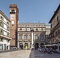


- UNESCO
Photo: Patafisik, CC BY-SA 4.0 · Wikimedia Commons
Archaeological site
Building in Verona, Italy
The Capitolium of Verona was a building complex forming part of the Forum area of the Roman city, it corresponds to today's Piazza delle Erbe. Parts of the cryptoporticus can be seen and visited under the loggia of Corte Sgarzerie, inside the crypt of the church of San Benedetto al Monte and under Palazzo Maffei.
The building complex was built in the second half of the 1st century BC and was completed in 20 BC to celebrate the raising of the city's status to that of Roman municipium. The style of the temple building, intentionally archaic and inspired by the Roman Capitolium, underlines the political, rather than religious, value of the complex. A double portico that surrounded it on three sides, excluding the front one, was later erected by Marcus Magius, as shown by an inscription found at the same site. The commission of the temple is unknown: it is assumed that it may have been a group of senators strongly linked to Rome if not even Gaius Julius Caesar, whom, according to the sources, was certainly present in Verona at the time.
A sestertium of Domitian, dating back to the year 95 A.D., attests to a rebuilding of a portico wall: this coin was placed intentionally, either to remember the intervention, or with talismanic functions. Supporting the latter hypothesis is the fact that the coin depicts Jupiter: it may have been put there to evoke the protection of the deity to whom the complex was dedicated.
The cultural continuity is attested by a statue base bearing two later inscriptions: the first is the dedication of a statue to a woman of high rank, a priestess of the deified Plotina. The second inscription, dating from the end of the 2nd century AD or the beginning of the 3rd century AD, is located on the opposite side and is a dedication to Jupiter Optimus Maximus made by the Ordo Veronensium: the council of decuriones that administered the city. Another inscription, dating from about 379-380 A.D., mentions the moving of a bronze statue from the temple to the Forum, as it lay abandoned: this is an indication of the decline of the structures, probably as a result of the spread of the Christian religion and the weakening of the political structure.
At the end of the fourth century AD a fire destroyed all or part of the triporticus. A few decades later, around the fifth century AD, the entire structure was stripped bare, as it was in a state of abandonment and degradation. At the end of the seventh century AD the vaults that propped up the cryptoporticus collapsed. Other structures thus overlapped the ruins of the Roman buildings: an early medieval compartment, still visible in the archaeological area of Corte Sgarzerie; a tower house of which only the foundations remain; and finally the Mangano Loggia.
The imposing Capitolium complex, which stood on an artificial embankment of about 80 meters long, included the temple dedicated to the Capitoline Triad, which was accessed from the maximum decumanus and from the Forum through a staircase, and a portico that surrounded it on three sides, and that probably also functioned as city archive. Under the Capitolium there was a cryptoporticus, an element that currently constitutes the only visitable area of the archaeological complex, also accessible from the decumanus maximum via a staircase.
Although the monumental typology is similar to an architectural model used in Roman constructions from the end of the second century BC, it is believed to be of a later dating, in conjunction with the use of the opus incertum in the Po area. Thanks to the dating of a monumental epigraph found in the excavations of the western peribolos of the temple, we now know the name of the builder of the portico and the cryptoporticus:
M(arcus) Magius L(uci) f(ilius) cryptam fecit et porticus reposut d(e) p(ecunia) s(ua)
This epigraph was found in a structural element, similar to a frieze, it was made after the foundation structures of the temple area, and it is therefore contemporary with the structure of the Capitolium and offers a precise dating. In this important inscription, obtained from a block of limestone, a name that in Roman times was known not only in Verona, but also in the neighboring territories, is mentioned. The shape of the letters, the lack of a cognomen and other data have led paleographers to a probable dating of this dedicatory inscription, and therefore of the complex itself, to the first decade of the second half of the 1st century BC. …
During the excavations in the cryptoporticus, two bronze fragments belonging to the cadastral tables of the Roman city were found. These constitute a rare example of an ancient cadastre, in this case rural, with administrative and fiscal functions.
One of the two fragments is the upper left corner of a bronze panel on which a grid of horizontal and vertical lines has been engraved. Inserted within each box we can see the coordinates of the holdings on the centuriated land, the measurements in jugerums and the names of the owners. This fragment is dated between 40 and 30 BC, and it has names such as those of Caius Cornelius Agatho and Marcus Clodius Pulcher, already known from other Veronese inscriptions of the same period. The second fragment, also dated to the second half of the 1st century BC, has quadrangular engravings. Of the seven preserved cells, only in the central one the names of the owners can be read; they have a clear Celtic origin (Bituci, Vindili, Segomari), however in this case the coordinates are missing. Worthy of noting is the fact that they are linked to small plots of land compared to those reported on the first fragment.
Text from Wikipedia, the free encyclopedia, under CC BY-SA 4.0. Full article: «Capitolium».
Distances are as the crow flies, not walking or driving.


Capitolium is in Verona, in the province of Verona (Veneto), Italy. Address: Corte Sgarzarie, 8, 37121, Verona. GPS coordinates: 45.44349, 10.99576.
Nearby you’ll find: Archaeological area of Corte Sgarzerie (0 m away), Torre del Gardello (100 m away), Palazzo Radice (100 m away).
Text. Wikipedia, the free encyclopedia (CC BY-SA 4.0).
Data. Wikidata (CC0); opening hours and contacts OpenStreetMap (ODbL).
Photos. Wikimedia Commons, author and licence on every image.
Updated 28 October 2026. All sources and licences