



- UNESCO
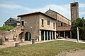
Photo: Cervellin at Italian Wikipedia, CC BY-SA 3.0 · Wikimedia Commons
Archaeological site
Ancient city in Veneto and archaeological site in the Italian municipality of Quarto d'Altino (VE)
Quarto d'Altino (VE), Veneto
Altinum (in Altino, a frazione of Quarto d'Altino) was an ancient town of the Veneti 15 km southeast of modern Treviso, close to the mainland shore of the Lagoon of Venice. It was also close to the mouths of the rivers Dese, Zero and Sile. A flourishing port and trading centre during the Roman period, it was destroyed by Attila the Hun in 452. The town recovered, but was later abandoned when sea-borne sand began to cover it over. Its inhabitants moved to Torcello and other islands of the northern part of the lagoon.
Today Altinum is an archaeological area and has a national archaeological museum.
Altinum was a Venetic settlement. The earliest human presence in the area is dated to the 10th century BCE and is related to hunter-gatherer groups. The earliest evidence of a settlement nucleus is dated from the mid-8th century to the mid-7th century BCE. In the 7th century BCE the settlement moved slightly to the northwest, in its historical location. A sacred area which is dated to the late 6th century BCE and developed in the 5th and 4th centuries BCE had votive offering objects from Greek, Magna Graecian, Etruscan and Celtic areas. This suggests that Altinum was the main port of the Veneti in the proto-historical age.
Archaeology indicates that in the late 6th/early 5th century BC, the Veneti had precocious contact with Celtic areas through the communication routes along the rivers Adige and Piave in the major centres in the plain of the River Po (Este and Padua and the Adriatic ports such as Atria, modern Adria, and Altinum). There was a trading relationship between high-ranking families. There was a degree of intermarriage. Some Celts settled in the region. Celtic gift and fashion objects appear in the burials of important families.
In the early 4th century BCE, the Gauls invaded the plain of the Po as far as Verona. This led to a gradual ethnic mixing and loss of cultural identity, especially in the border areas of the Veneti: Verona in the west and the Lagoon of Venice and the Piave valley in the east. In some places there was at times a transition from the traditional practice of cremation to inhumation and the deposition of weapons in burials, which was an exception to Veneti funerary culture. An example of this was found in a cemetery in Altinum. Such evidence suggests that inter-ethnic relations went beyond just trade and that there were clusters of foreign settlers. Perhaps they were traders, workers and/or mercenaries. …
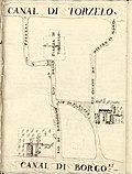
Archaeological finds indicate that Altinum's perimeter was marked by waterways beyond which there were cemetery areas. The abundance of watercourses gives the picture of a town deeply tied to water, which was characteristic of towns in the Veneto. The transformation of Altinum from a Veneti to a Roman town started with the reorganisation of its marshy environment through the regulation of its waters and the expansion of its canal network. The main work was the digging of the Silocello canal to link the River Sile (which was to the north of the town) to the channel, which today is called Santa Maria and which flowed to the south of the town from the River Dese to the lagoon. The most important architectural finds are a town gate on the canal which marked the northern edge of the town, another public building which faced the canal which marked the southern edge of the town, and a temple close to the Santa Maria channel which was restructured in a monumental form from a 5th-century BCE wooden structure. (See the "Port and canals" section for Altinum's canals)
In 225 BCE the Veneti and Romans established an alliance treaty in the run-up to the Battle of Telamon between Rome and an alliance between the Insubres and Boii Gallic tribes of northern Italy and Gaesatae mercenaries. The foundation of the colony of Aquileia, in Celtic territory, as a fortress to protect northern Italy from invasions from the northeast and east was an important moment in the process of Romanisation of the Veneti and Altinum, which is traceable to the first half of the 2nd century BCE. Altinum came to be a half-way port and stopover between Ravenna and the new and important colony. Its port grew in size. This was also due to the Romans promoting sea trade in the upper Adriatic Sea.
The process of Romanisation was in part driven by the presence of Roman, Latin and Italic merchants attracted to this port by lucrative trade. Inscriptions attest to an early presence of the Publicia, Barbia, Cossutia and Saufeia families in Aquileia and Virunum (modern Magdalensberg), a town in Noricum (in present-day Austria) where there was iron mining. These were families of equestrian rank (the Roman entrepreneurial class). They went to Aquileia from central Italy, and from there they spread to the northern markets, including Altinum. …
Marcus Valerius Martialis (Martial), the 1st-century poet, wrote: "You banks of Altinum, that rival the rural beauties of Baiae,... and you, Aquileia... You shall be the haven and the resting-places of my old age, if my retirement be at my own disposal." Baiae was a popular seaside resort in the Bay of Naples which was very fashionable among rich Romans.
Strabo, the 1st-century BCE geographer, gave a description of northern Italy and the Veneto: "The whole of this country is full of rivers and marshes, especially the district of the Veneti, which likewise experiences the tides of the sea. This is almost the only part of our sea [The Mediterranean] which is influenced in the same manner as the ocean, and, like it, has ebb and flood tides. In consequence most of the plain is covered with lagoons. The inhabitants have dug canals and dikes, after the manner of Lower Egypt, so that part of the country is drained and cultivated, and the rest is navigable. Some of their cities stand in the midst of water like islands, others are only partially surrounded. Such as lie above the marshes in the interior are situated on [navigable rivers]... continually swelled by the rains and snows."
Strabo also described Ravenna and Altinum: "Situated in the marshes is the great [city of] Ravenna, built entirely on piles, and traversed by canals, which you cross by bridges or ferry-boats. At the full tides it is washed by a considerable quantity of sea-water, as well as by the river, and thus the sewage is carried off, and the air purified... It is a remarkable peculiarity of this place, that, though situated in the midst of a marsh, the air is perfectly innocuous... Another remarkable peculiarity is that of its vines, which, though growing in the marshes, make very quickly and yield a large amount of fruit, but perish in four or five years. Altinum stands likewise in the marshes, its situation being very similar to that of Ravenna." …
By the 10th century, the area of Altinum was totally abandoned. The bishop of Altinum moved to the island of Torcello (see above). The bishops of Torcello stressed their Altinum lineage and retained the juridical title of bishop of Altinum for centuries. The monks of the monastery of Santo Stefano moved to the Tumba Leseda
island (nowadays it is called La Salina) in the archipelago of the settlement of Ammiana in 900. They established the monastery of Santi Felice e Fortunato. Both settlements were in the northern part of the Lagoon of Venice.
Documentation about the area in this period is scant and comes mostly from ecclesiastic institutions (the monasteries of Santi Felice e Fortunato and of San Giorgio Maggiore and the bishop of Torcello) or from families which owned land in the area (the Carbonara, Collalto, Marcello and Querini). A 1095 text attested to the existence of an Altino Maiore and an Altino Pitulo, which indicates that there was still a village and that it may have split into two parts. The text also indicates that the churches of Santa Maria (the old cathedral), San Martino e Sant'Apollinare still existed.
In 1388, when the Republic of Venice annexed the Treviso area, which reached the mainland shore of the Lagoon of Venice, wealthy Venetians founded an agricultural village close to the shore and to the site of Altinum. It was named San Michele del Quarto after a small church which was four Roman miles from Altinum.
Text from Wikipedia, the free encyclopedia, under CC BY-SA 4.0. Full article: «Altinum».
Distances are as the crow flies, not walking or driving.


Altinum is in Quarto d'Altino, in the province of Venezia (Veneto), Italy. GPS coordinates: 45.54639, 12.39889.
Yes: entry is free on the first Sunday of every month, under the Italian “Domenica al museo” scheme.
Nearby you’ll find: Museo archeologico nazionale di Altino (500 m away), Fort Pepe (2.2 km away), Museo provinciale di Torcello (5.5 km away).
Text. Wikipedia, the free encyclopedia (CC BY-SA 4.0).
Data. Wikidata (CC0); opening hours and contacts OpenStreetMap (ODbL).
Photos. Wikimedia Commons, author and licence on every image.
Updated 28 October 2026. All sources and licences