


Photo: Federico_Milesi, CC BY-SA 4.0 · Wikimedia Commons
Abbey / Monastery, 15th century
Sant'Antonio di Ranverso Abbey
Church
Buttigliera Alta (TO), Piedmont
At a glance
- Type
- Abbey / Monastery
- Period
- Middle Ages, 15th century
- Style
- Gothic architecture
- Protection
- Italian national heritage
- Coordinates
- 45°04′52″ N, 7°26′58″ E
- Address
- Località Sant'Antonio di Ranverso, 10090, Buttigliera Alta
History and description
The Abbey of Sant'Antonio di Ranverso is a religious complex at Buttigliera Alta, in the Metropolitan City of Turin, northern Italy.
History
The monastery (also known as preceptory) complex was founded in 1188 by Humbert III of Savoy, who give it to the Regular Canons of St. Anthony of Vienne, as a restoration point for pilgrims and a treatment center for people infected by ergot. With the outbreak of the Black Death in the 15th century, the abbey also took care of the new contagium. St. Anthony was chosen due to its widespread depiction in company of a small pig, an animal whose fat was used for the treatment of the plague.
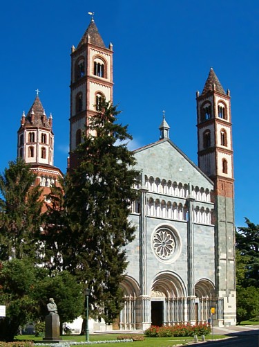
The complex was modified and rebuilt several times. It initially included a hospital, of which only the façade remain, the preceptory itself and the church. The latter appears today in Lombard-Gothic style, after its renovation in the 14th-15th centuries. Annexed to it is the bell tower, also in Gothic style (14th century).
The interior was decorated with numerous frescoes starting from the 13th century, some of which painted by Giacomo Jaquerio in the early 15th century. Also by him is the Ascension to the Calvary, in the sacristy. In the presbytery is a polyptych by Defendente Ferrari (1531).
Text from Wikipedia, the free encyclopedia, under CC BY-SA 4.0. Full article: «Sant'Antonio di Ranverso Abbey».
Timeline
- 15th centuryBuilt
Events and people from Wikidata (CC0).
Photos
Getting there
RostaTrain, nearest
1.0 km as the crow flies
Sant'Antonio di Ranverso AbbeyLocalità Sant'Antonio di Ranverso, 10090, Buttigliera Alta
Aeroporto di Torino20.7 km
Distances are as the crow flies, not walking or driving.
Loading map…
Nearby
See on the mapMore abbeys and monasteries in Piedmont



- Free 1st Sunday
Frequently asked questions
Where is Sant'Antonio di Ranverso Abbey?
Sant'Antonio di Ranverso Abbey is in Buttigliera Alta, in the province of Torino (Piedmont), Italy. Address: Località Sant'Antonio di Ranverso, 10090, Buttigliera Alta. GPS coordinates: 45.08111, 7.44944.
How old is Sant'Antonio di Ranverso Abbey?
Wikidata dates it to the 15th century.
What else is there to see near Sant'Antonio di Ranverso Abbey?
Nearby you’ll find: Torre dell'Orologio (4.1 km away), Avigliana Castle (4.4 km away), Museo d'arte contemporanea del castello di Rivoli (4.9 km away).
Sources and licences
Text. Wikipedia, the free encyclopedia (CC BY-SA 4.0).
Data. Wikidata (CC0); opening hours and contacts OpenStreetMap (ODbL).
Photos. Wikimedia Commons, author and licence on every image.
Credits for the 8 photos
- Buttigliera Alta - Abbazia di Sant'Antonio di Ranverso - 2025-09-29 15-44-50 002 — Federico_Milesi, CC BY-SA 4.0
- Abbazia di Sant'Antonio di Ranverso — Fernando.tassone, CC BY-SA 4.0
- Buttigliera Alta - Abbazia di Sant'Antonio di Ranverso - 2025-09-29 15-44-50 001 — Federico_Milesi, CC BY-SA 4.0
- Buttigliera Alta - Abbazia di Sant'Antonio di Ranverso - 2025-09-29 15-49-51 001 — Federico_Milesi, CC BY-SA 4.0
- Buttigliera Alta - Abbazia di Sant'Antonio di Ranverso 003 — Elio Pallard, CC BY-SA 4.0
- Precettoria Sant'Antonio di Ranverso — Fernando.tassone, CC BY-SA 4.0
- Sant'Antonio di Ranverso — Fernando.tassone, CC BY-SA 4.0
- AntoniodiRanverso — Georgius LXXXIX, CC BY-SA 3.0
Updated 28 October 2026. All sources and licences