


- Most beautiful villages
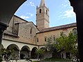
Photo: Alessandro Vecchi, CC BY-SA 4.0 · Wikimedia Commons
Historic village
Italian comune
Taggia is a comune (municipality) in the Province of Imperia in the Italian region Liguria, located about 110 kilometres (68 miles) southwest of Genoa and about 15 km (9 mi) west of Imperia. It has around 13,000 inhabitants.
Taggia borders the following municipalities: Badalucco, Castellaro, Ceriana, Dolcedo, Pietrabruna, Riva Ligure, and Sanremo. It is one of I Borghi più belli d'Italia ("The most beautiful villages of Italy").
Tombs dating from the 10th-7th centuries BC have been found in the area of Taggia. During the Roman domination it was an important commercial port, known as Costa Balenae. After the fall of the Western Roman Empire, the old centre was damaged by the invasion of Rotharis's Lombards and then by a landslide in 690. The inhabitants moved to a new walled settlement, called Tabia. Despite its defences, in 889 it was sacked and razed to the ground by the Saracens.
The rebuilt burgh became in 1153 a fief of the Clavesana family, but soon later it was acquired by the Republic of Genoa. In 1273 it became an autonomous commune, later receiving a podestà named in Genoa, under which it remained until its disappearing in the Napoleonic Wars. Later it was part of the Kingdom of Sardinia (1815) and of the Kingdom of Italy (1861).
Basilica of San Giacomo and San Filippo (1675–1681), built on an 11th-century Romanesque church.
Church of Santa Maria del Canneto (10th or 14th century).
Church of San Martino di Tours, housing 15th-century frescoes.
Convent of San Domenico (160–1490). It has some pictures painted by Ludovico Brea.
Text from Wikipedia, the free encyclopedia, under CC BY-SA 4.0. Full article: «Taggia».
Distances are as the crow flies, not walking or driving.


Taggia is in Taggia, in the province of Imperia (Liguria), Italy. GPS coordinates: 43.84386, 7.85093.
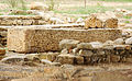
Nearby you’ll find: Saint Dominic monastery (Taggia) (1.4 km away), Costa Balenae (1.7 km away), Torre dell'Arma (1.8 km away).
Text. Wikipedia, the free encyclopedia (CC BY-SA 4.0).
Data. Wikidata (CC0); opening hours and contacts OpenStreetMap (ODbL).
Photos. Wikimedia Commons, author and licence on every image.
Updated 28 October 2026. All sources and licences