


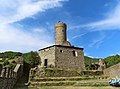




Photo: Davide Papalini, CC BY 2.5 · Wikimedia Commons
At a glance
- Type
- Historic village
- Elevation
- 342 m above sea level
- Area
- 23,740,000 m²
- Coordinates
- 44°32′17″ N, 8°41′52″ E
- Address
- Piazza Giacomo Matteotti, 3
History and description
Campo Ligure (locally Campo) is a comune (municipality) in the Metropolitan City of Genoa in the Italian region Liguria, located about 37 kilometres (23 mi) northwest of Genoa.
Campo Ligure borders the following municipalities: Bosio, Masone, Rossiglione, Tiglieto. It is one of I Borghi più belli d'Italia ("The most beautiful villages of Italy").
History
The place name refers to a 3rd-century AD Roman fortified settlement built during the reign of Emperor Aurelian, reinforced by the Byzantines in the 6th century. The first parish, San Michele, is probably dating back to the 10th century. Between the 12th and 13th century various families led the administration of Campo, until the year 1329, when it becomes a small fief within the Holy Roman Empire, surrounded by the territory of the Republic of Genoa.
In July 1600 the Republic of Genoa increased control of the small enclave, banishing any local opposition to its rule. In the 18th century the town saw a gradual buildup of manufacturing activities (iron production and processing, silk spinning mills, paper mills, lime pits, forestry and agriculture), as well as the birth of the republican municipality, which joined the Ligurian Republic in 1797.
In 1805 the town, then called Campo Freddo, was included in the French Empire of Napoleon I; after the 1815 Congress of Vienna it became part of the Kingdom of Sardinia.
In 1884 the village's name was changed from Campo Freddo (derived from “feudo” -fief- or possibly the German word “frei” -free- ) to Campo Ligure. That year also saw the opening of the first goldsmith shop dedicated to filigree.
Main sights
Castle, built by the Spinola family of Genoa since 1309
Palazzo Spinola. Built in the 14th century, it was enlarged in 1693
Medieval bridge on the Stura river. The original structure dated to the 9th century, but it was rebuilt several times starting from the 18th century.
Text from Wikipedia, the free encyclopedia, under CC BY-SA 4.0. Full article: «Campo Ligure».
Photos
Getting there
Campo Ligure-MasoneTrain, nearest
800 m as the crow flies
Campo LigurePiazza Giacomo Matteotti, 3
Aeroporto Internazionale di Genova - Cristoforo Colombo18.1 km
Distances are as the crow flies, not walking or driving.
Loading map…
Nearby
See on the mapMore historic villages in Liguria

- Most beautiful villages


- Most beautiful villages

- Most beautiful villages
- Most beautiful villages
Frequently asked questions
Where is Campo Ligure?
Campo Ligure is in Campo Ligure, in the province of Genova (Liguria), Italy. Address: Piazza Giacomo Matteotti, 3. GPS coordinates: 44.53809, 8.69779.
What else is there to see near Campo Ligure?
Nearby you’ll find: Museo civico della Filigrana Pietro Carlo Bosio (100 m away), Palazzo Spinola (100 m away), Castello di Campo Ligure (200 m away).
Sources and licences
Text. Wikipedia, the free encyclopedia (CC BY-SA 4.0).
Data. Wikidata (CC0); opening hours and contacts OpenStreetMap (ODbL).
Photos. Wikimedia Commons, author and licence on every image.
Credits for the 9 photos
- Campo Ligure-IMG 0302 — Davide Papalini, CC BY 2.5
- Angassino River in Campo Ligure — Андрей Романенко, CC BY-SA 4.0
- Badeplatz in Campo Ligure an der Stura — Usien, CC BY-SA 3.0
- Bosio-Campo Ligure 1 — Andre86, CC0
- Campo Ligure - Campanile Natività di Maria Vergine e castello spinola — Luca Aless, CC BY-SA 4.0
- Campo Ligure - Castello e campanile Chiesa — Luca Aless, CC BY-SA 4.0
- Campo Ligure - Panorama e ponte S. Michele — Luca Aless, CC BY-SA 4.0
- Campo Ligure (GE) - panorama notturno con neve — Simone Piombo, CC BY-SA 4.0
- Campo ligure 01 — Alessio Sbarbaro User_talk:Yoggysot, CC BY-SA 3.0
Updated 28 October 2026. All sources and licences