


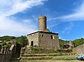


Photo: Parma1983, CC BY-SA 4.0 · Wikimedia Commons
Abbey / Monastery, 1120
Tiglieto Abbey
Cistercian Abbey of Tiglieto, Italy
At a glance
- Type
- Abbey / Monastery
- Period
- Middle Ages, 1120
- Dedicated to
- Mary
- Coordinates
- 44°31′20″ N, 8°36′13″ E
History and description
Tiglieto Abbey (Badia di Tiglieto, also known as Santa Maria alla Croce de Civitacula) is a monastery in Tiglieto, Liguria, northern Italy. It was the first Cistercian abbey to be founded in Italy, and also the first outside France.
The abbey is located on the left bank of the brook known as the Orba, 382 metres above sea level in the Province of Genoa, near the border of the Region of Piedmont.
History
The abbey, founded in 1120 at the instigation of Peter I of Tarentaise, was a daughter house of La Ferté Abbey. The first abbot was probably Opizzone. It may have gained the name Tiglieto (Latin: Teletum) after being given the estate of that name by the Margrave Anselm of Ponsone in 1131.
Communities from Tiglieto settled Staffarda Abbey and Casanova Abbey as its daughter houses, both in the present Region of Piedmont.
In 1205, Gerardo da Sesso was elected abbot. He became a cardinal in 1211.
In 1442, through Pope Eugenius IV, Tiglieto became an abbey in commendam. In 1648 it was turned into a family estate of the last commendatory abbot, Cardinal Raggio, and dissolved. In 1747 the area was occupied by the Austrians, who shortly afterwards were driven out by the Genoese.
In 2000 Tiglieto was reoccupied by the Cistercians.
Buildings and precinct
The church is a primitive Romanesque brick basilica; the original side-chapels were removed in the 14th century to make way for a new east end. The nave was vaulted in the Baroque period, and a new choir at the west end was added at the same time, as was a Baroque campanile. The conventual buildings are to the south of the church. The early Gothic chapter house in the east range has survived, with a square chapter room with nine bays from the early 13th century and symmetrical triforium windows looking onto the central courtyard and the site of the cloister, no longer extant, with the dormitory with bricked-up windows in the upper storey, as have the sacristy, the Fraternei and to the south the refectory building, as well as the lay brothers' block in the west, now converted for residential purposes. The entire precinct was renovated for the new community that took over the premises in 2000.
Text from Wikipedia, the free encyclopedia, under CC BY-SA 4.0. Full article: «Tiglieto Abbey».
Timeline
- 1120Built
People
Events and people from Wikidata (CC0).
Photos
Getting there
RossiglioneTrain, nearest
7.2 km as the crow flies
Tiglieto Abbey
Aeroporto Internazionale di Genova - Cristoforo Colombo22.5 km
Distances are as the crow flies, not walking or driving.
Loading map…
Nearby
See on the mapMore abbeys and monasteries in Liguria


Frequently asked questions
Where is Tiglieto Abbey?
Tiglieto Abbey is in Tiglieto, in the province of Genova (Liguria), Italy. GPS coordinates: 44.52222, 8.60361.
How old is Tiglieto Abbey?
Wikidata dates it to 1120.
What else is there to see near Tiglieto Abbey?
Nearby you’ll find: Palazzo del Rostiolo (6.4 km away), Campo Ligure (7.7 km away), Museo civico della Filigrana Pietro Carlo Bosio (7.7 km away).
Sources and licences
Text. Wikipedia, the free encyclopedia (CC BY-SA 4.0).
Data. Wikidata (CC0); opening hours and contacts OpenStreetMap (ODbL).
Photos. Wikimedia Commons, author and licence on every image.
Credits for the 4 photos
- Abbazia di Santa Maria alla Croce (Tiglieto) - facciata 2022-07-09 — Parma1983, CC BY-SA 4.0
- Abbazia di Santa Maria alla Croce (Tiglieto) - lato est del chiostro 2022-07-09 — Parma1983, CC BY-SA 4.0
- Badia di Tiglieto-IMG 0335 — Davide Papalini, CC BY-SA 3.0
- Procesión en la abadía de Tiglieto, de Serafín Avendaño (Museo del Prado) — Serafín Avendaño, Public domain
Updated 28 October 2026. All sources and licences