




Photo: Cicciotto, CC0 · Wikimedia Commons
Archaeological site
Ponte di San Vito
Roman bridge near Rimini, Italy
At a glance
- Type
- Archaeological site
- Coordinates
- 44°05′12″ N, 12°27′12″ E
History and description
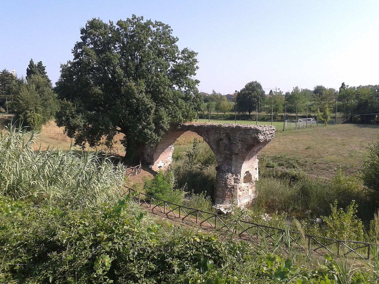
The Roman Bridge of San Vito (Italian: Ponte romano di San Vito), also locally known as the Pontaccio (Romagnol: e Puntaz, lit. 'ugly bridge'), was a Roman bridge in San Vito, a frazione on the borders of Rimini, Santarcangelo di Romagna, and San Mauro Pascoli, in the region of Emilia-Romagna, northern Italy.
Dating to the reign of emperor Augustus, the bridge was on a route of the Via Aemilia, the ancient Roman road running between Ariminum (modern Rimini) and Placentia (Piacenza). The bridge crossed the river Uso, which now flows a few metres to the east. In the 14th century, Galeotto I Malatesta, Lord of Rimini, replaced the bridge; an arch of the medieval bridge remains extant above the Augustan stones. The stones of the bridges, prized for their excellent quality, were quarried over subsequent centuries, contributing also to restorations of Rimini's Ponte di Tiberio. In October 2022, Rimini's municipal government incorporated the extant arch into a public park.
The Augustan bridge was likely monumental, with a total length of approximately 90 metres (300 feet), and numbering eight or more arches.
History
The Ponte di San Vito was almost certainly built during the reign of Roman emperor Augustus, given both the stones and a milestone recovered a few metres from the bridge in 1949, which attributes the restoration of the road to Augustus' commission in 2 BC. It was built on the Via Aemilia, an ancient Roman road between Ariminum (modern Rimini) and Placentia (Piacenza) that dates to Marcus Aemilius Lepidus in 187 BC. The section of the Via Aemilia between Savignano sul Rubicone and Santa Giustina, now known as the Via Emilia Vecchia, replaced an earlier routing of the road through Santarcangelo di Romagna. The Augustan bridge likely replaced an earlier bridge. It crossed the river Uso, which flows from Perticara, a frazione of Novafeltria, to the Adriatic Sea in Bellaria–Igea Marina. The river now flows a few metres to the bridge's east.
In the 14th century, Galeotto I Malatesta, Lord of Rimini, replaced the Augustan bridge in an effort to reduce the importance of Santarcangelo, which had become a vicariate under the Avignon popes. An arch of the medieval bridge remains extant above the Augustan stones.
In later centuries, following the medieval bridge's collapse, San Vito was renowned as a quarry, using the stones from the Augustan bridge, which were notable for their excellent quality. The stones were used to repave the floor of Rimini's Santa Colomba cathedral, and may also have been used for the construction of the Tempio Malatestiano. In 1550, Leandro Alberti wrote in his Descrittione di tutta Italia that "there was anciently here on the Via Emilia a stone bridge... of which the vestiges appear to this day".
In 1680, Agostino Martinelli, an amateur Ferrarese architect entrusted with restoring an arch of Rimini's Ponte d'Augusto, recovered blocks of white Aurisina limestone from the river at San Vito; the blocks were identical to those of the Riminese bridge. In 1735, Giulio Alberoni allowed further "marbles that remain of the ancient ruins... that are now uselessly underwater" to be removed for the restoration of the Ponte d'Augusto. …
Architecture
The bridge is made of white limestone blocks from Aurisina, known as Istrian stone. It also used ammonitic red limestone blocks from Verona, similar to those used as a foundation slab in the Augustan bridge at Savignano sul Rubicone.
The bridge's total length was likely approximately 90 metres (300 feet), longer than Rimini's Ponte di Tiberio, as also suggested by the number of recovered stones. In 2019, to explain the bridge's length, Rimondini hypothesised that there may have been two bridges, crossing the Uso at different meanders, to which Cartoceti replied that, locally, the Romans more commonly built one large bridge over wide rivers than two separate ones.
An 1825 sketch by local engineer Maurizio Brighenti indicated the area where the foundations of the bridge's piers would emerge from the riverbed during dry seasons. The sketch suggested that the bridge numbered eight or more arches, ending on the right bank of the present-day Uso. After being published by Rimondini, Brighenti's sketches were lost in Forlì's state archives.
The 2004 excavation suggested that two arches had a diameter of at least 5.6 metres (18 feet), while the pier had a thickness of 2.9 metres (9.5 feet).
Rubicon hypothesis
For historians that identify the Uso with Julius Caesar's historic crossing of the Rubicon in 49 BC, which opened Caesar's civil war, the Ponte di San Vito would have been the point of Caesar's crossing. With the exception of Luigi Tonini, most Riminese local historians favoured the Uso's claim over that of Savignano di Romagna's Fiumicino and the Pisciatello, a tributary of the Fiumincino that flows nearer Cesena. Local historians and archaeologists have advocated further archaeological excavation of the Ponte di San Vito to understand these uncertainties.
Other supporters of the Uso's claim contend that the point of Caesar's crossing was not San Vito, but by a pine forest near the Uso's mouth at Bellaria, along the Via Popilia.
Writing about San Vito in 1681, Martinelli, who restored the Ponte di Tiberio, marvelled that such a grand bridge had been built for "a small stream to be crossed with jumps". He opined:
If I did not know of the unsettled controversy about determining which was the famous ancient Rubicon, I would almost dare say it was this one, where the stones were removed, because it is believable, that in the place where foreign arms were to be avoided, there was, as was customary for the ancient Roman Generosity, a grand structure, in which the Decree was inscribed in large characters, for it is certain, that a grand limit had to be assigned, that made a firm point to the passage of enemy arms, whether this was the Bridge, which curved over the same Rubicon, or another grand structure on the banks of the same.
In Alberoni's 1735 grant for more stones to be removed from the quarry, the bridge at San Vito is called "the ancient ruins of the Bridge of the Rubicon River vulgarly called the Uso that are uselessly underwater".
On 4 August 1933, the government of Benito Mussolini, Italy's fascist dictator, by the decree of Victor Emmanuel III, renamed Savignano as Savignano del Rubicone, according government support to the Fiumicino's claim. Despite the official support for the Fiumincino, which was renamed the Rubicon, local historians continued to debate the site of the ancient river, believing that the decision was arbitrary and politically motivated. In the post-war years, Augusto Campana, a local historian who wrote on the Via Emilia, expressed interest in San Vito's claim. …
Text from Wikipedia, the free encyclopedia, under CC BY-SA 4.0. Full article: «Ponte di San Vito».
Getting there
Santarcangelo di RomagnaTrain, nearest
1.8 km as the crow flies
Ponte di San Vito
Motonave Super Tayfun5.9 km
Aeroporto internazionale Federico Fellini14.6 km
Distances are as the crow flies, not walking or driving.
Loading map…
Nearby
See on the mapMore archaeological sites in Emilia-Romagna

- Free 1st Sunday

- UNESCO


- Free 1st Sunday

Frequently asked questions
Where is Ponte di San Vito?
Ponte di San Vito is in Santarcangelo di Romagna, in the province of Rimini (Emilia-Romagna), Italy. GPS coordinates: 44.08656, 12.45347.
What else is there to see near Ponte di San Vito?
Nearby you’ll find: Museo del bottone (2.6 km away), Rocca Malatestiana (2.8 km away), Roman bridge on Rubicone River (4.6 km away).
Sources and licences
Text. Wikipedia, the free encyclopedia (CC BY-SA 4.0).
Data. Wikidata (CC0); opening hours and contacts OpenStreetMap (ODbL).
Photos. Wikimedia Commons, author and licence on every image.
Credits for the 1 photos
- Antico ponte romano di San Vito, Romagna (2013) — Cicciotto, CC0
Updated 28 October 2026. All sources and licences