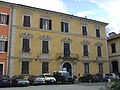
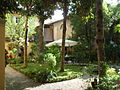
At a glance
Period Modern era, 2002
Area 2,600 m²
Protection Italian national heritage
Coordinates 43°50′28″ N, 10°29′59″ E
Address San Romano, 4 - Lucca About No English description yet Opening hours and directions are on this page. The full story is on Italian Wikipedia.
Read it in Italian Timeline 2002 Founded and opened
Events and people from Wikidata (CC0 ).
Getting there 700 m as the crow flies
Museo del fumetto e dell'immagine San Romano, 4 - Lucca
Aeroporto internazionale Galileo Galilei 19.3 km
Distances are as the crow flies, not walking or driving.
Palazzo della Magione del Tempio Historic villa / palace, Lucca 0.1 km Paolo Cresci Museum for the History of the Italian Emigration Museum, Lucca 0.1 km Palazzo Brancoli Pantera Historic villa / palace, Lucca 0.2 km Ducal Palace, Lucca Historic villa / palace, Lucca 0.2 km Fortezza Augusta Fortress / Tower, Lucca 0.2 km Teatro di San Girolamo Historic theatre, Lucca 0.3 km Palazzo Pretorio, Lucca Historic villa / palace, Lucca 0.3 km Palazzo Mansi National Museum Museum, Lucca 0.3 km More museums in Tuscany Museum, 1784 Florence (FI)
Museum, 1871 Florence (FI)
Museum, 1930 Florence (FI)
Museum, 1828 Florence (FI)
Museum, 1545 Florence (FI)
Museum, 1221 Florence (FI)
See all museums in Tuscany
Things to see in Lucca: 108 historic places
Frequently asked questions Where is Museo del fumetto e dell'immagine? Museo del fumetto e dell'immagine is in Lucca, in the province of Lucca (Tuscany), Italy. Address: San Romano, 4 - Lucca. GPS coordinates: 43.84113, 10.49961.
How old is Museo del fumetto e dell'immagine? Wikidata dates it to 2002.
What else is there to see near Museo del fumetto e dell'immagine? Nearby you’ll find: Palazzo della Magione del Tempio (100 m away), Paolo Cresci Museum for the History of the Italian Emigration (100 m away), Palazzo Brancoli Pantera (200 m away).