

Photo: Sacranon, Public domain · Wikimedia Commons
Fortress / Tower, 19th century
Quadrilatero
Defensive system of the Austrian Empire
At a glance
- Type
- Fortress / Tower
- Period
- Modern era, 19th century
- Coordinates
- 45°17′39″ N, 10°58′06″ E
About
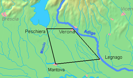
The Quadrilatero (English: Quadrilateral, for greater specificity often called the "Quadrilateral fortresses") is the traditional name of a defensive system of the Austrian Empire in the Lombardy-Venetia region of Italy, which connected the fortresses of Peschiera, Mantua, Legnago and Verona between the Mincio, the Po, and the Adige Rivers. The name refers to the fact that on a map the fortresses appear to form the vertices of a quadrilateral. In the period between the end of the Napoleonic Wars and the Revolutions of 1848, they were the only fully modernized and armed fortresses within the Empire.
Starting from c. 1850, supplies and reinforcements were shipped to the positions through the new Venice-Milan railroad.
The experience of the Second Italian Independence War of 1859, in which rifled guns had been used for the first time by the Italian Army, pushed the Austrians to build a second line of eight forts, about 4 kilometers from the main line (completed in the spring of 1866), pivoting around Verona.
Text from Wikipedia, the free encyclopedia, under CC BY-SA 4.0. Full article: «Quadrilatero».
Timeline
- 19th centuryBuilt
Events and people from Wikidata (CC0).
Getting there
Isola della ScalaTrain, nearest
4.5 km as the crow flies
Quadrilatero
Aeroporto Valerio Catullo di Verona-Villafranca13.0 km
Distances are as the crow flies, not walking or driving.
Loading map…
Nearby
See on the mapMore fortresses and towers in Veneto


Frequently asked questions
Where is Quadrilatero?
Quadrilatero is in Legnago, in the province of Verona (Veneto), Italy. GPS coordinates: 45.29417, 10.96833.
How old is Quadrilatero?
Wikidata dates it to the 19th century.
What else is there to see near Quadrilatero?
Nearby you’ll find: Torre di Isola della Scala (2.8 km away), Archeological Museum of Isola della Scala (4 km away), Villa Canossa (8.6 km away).
Sources and licences
Text. Wikipedia, the free encyclopedia (CC BY-SA 4.0).
Data. Wikidata (CC0); opening hours and contacts OpenStreetMap (ODbL).
Photos. Wikimedia Commons, author and licence on every image.
Credits for the 1 photos
- QuadrilateroAustriaco — Sacranon, Public domain
Updated 28 October 2026. All sources and licences