

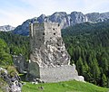

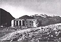


Photo: anonymous photographer during World War I, Public domain · Wikimedia Commons
Fortress / Tower
Forte Ruaz
Fort in Livinallongo del Col di Lana, Italy
At a glance
- Type
- Fortress / Tower
- Protection
- Italian national heritage
- Coordinates
- 46°29′51″ N, 11°55′03″ E
- Address
- Località Pezzei
History and description
Ruaz Roadblock is an Austro-Hungarian fortification built in Subrayon V of the Austro-Hungarian fortifications on the Italian border. The roadblock was built between 1897 and 1900, on the slopes of Col Di Lana, 1400m above sea level, in what is now Northern Italy. Along with Forte La Corte, the Ruaz roadblock made up the Buchensteinal wall. Ruaz had the job of controlling the Cordevole Valley and the road from Livinallongo to Arabba. Ruaz was armed with 6 unspecified guns all facing towards the Italian border.
World War I
The roadblock was relatively weak at the beginning of the war, and the Italians would have been able to overrun Corte and Ruaz easily and capture Col Di Lana, a major mountain with views over the local mountain passes. Instead, the Italian Chief of General Staff, Luigi Cadorna, thought that a decisive battle would be fought on the Isonzo River to the southeast. The lack of exploitation of the Austrian weakness led to months of bloody fighting on Col Di Lana, eventually earning the mountain the name Col di Sangue “Blood Mountain”.
Post-war
In 1972, Ruaz was renovated by the Waillant family and turned into a restaurant. The restaurant is linked to the hotel by a secret passage from the original fortification. 2 Austrian 10 cm guns are located in the square outside.
Text from Wikipedia, the free encyclopedia, under CC BY-SA 4.0. Full article: «Forte Ruaz».
Getting there
Address
Località Pezzei
Our data shows no stations, stops or car parks nearby. Check how to get there before you set out.
Loading map…
Nearby
See on the mapMore fortresses and towers in Veneto


Frequently asked questions
Where is Forte Ruaz?
Forte Ruaz is in Livinallongo del Col di Lana, in the province of Belluno (Veneto), Italy. Address: Località Pezzei. GPS coordinates: 46.49746, 11.91761.
What else is there to see near Forte Ruaz?
Nearby you’ll find: Werk Corte (700 m away), Andraz Castle (5.5 km away), Museo della Grande Guerra a Passo Fedaia (6 km away).
Sources and licences
Text. Wikipedia, the free encyclopedia (CC BY-SA 4.0).
Data. Wikidata (CC0); opening hours and contacts OpenStreetMap (ODbL).
Photos. Wikimedia Commons, author and licence on every image.
Credits for the 1 photos
- Sperre Ruaz — anonymous photographer during World War I, Public domain
Updated 28 October 2026. All sources and licences