




Photo: Adert, CC BY-SA 3.0 · Wikimedia Commons
At a glance
- Type
- Fortress / Tower
- Protection
- Italian national heritage
- Coordinates
- 45°34′33″ N, 10°49′53″ E
- Address
- Strada nazionale del Brennero
About
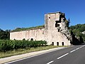
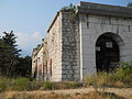
Fort Ceraino, also known as Fort Hlawaty, is a fortification built by Austria-Hungary near the municipality of Ceraino in Northern Italy. Ceraino was built between 1850 and 1851 at an altitude of 236m on Monte Pastello. Ceraino was part of a group of fortifications called Rivoli-Ceraino group. Originally, Ceraino was named Fort Hlawaty, named after the main architect of the fortifications of Verona, Lieutenant Field Marshal Johann von Hlavaty. Like most forts of the time, Ceraino was built out of quarried stone.
Fort Ceraino is surrounded by a moat that is 5m wide and 3-4m deep, which was chiseled out of stone. Within the moat are numerous rifle slits. Ceraino's garrison was between ½ and ¾ of an infantry company and between 100 and 115 artillery crew members.
Text from Wikipedia, the free encyclopedia, under CC BY-SA 4.0. Full article: «Forte Ceraino».
Photos
Getting there
DolcèTrain, nearest
3.2 km as the crow flies
Forte CerainoStrada nazionale del Brennero
Bardolino9.4 km
Aeroporto Valerio Catullo di Verona-Villafranca20.4 km
Distances are as the crow flies, not walking or driving.
Loading map…
Nearby
See on the mapMore fortresses and towers in Veneto


Frequently asked questions
Where is Forte Ceraino?
Forte Ceraino is in Dolcè, in the province of Verona (Veneto), Italy. Address: Strada nazionale del Brennero. GPS coordinates: 45.57586, 10.83147.
What else is there to see near Forte Ceraino?
Nearby you’ll find: Riparo Soman (800 m away), Forte Mollinary (1 km away), Fort Rivoli (1 km away).
Sources and licences
Text. Wikipedia, the free encyclopedia (CC BY-SA 4.0).
Data. Wikidata (CC0); opening hours and contacts OpenStreetMap (ODbL).
Photos. Wikimedia Commons, author and licence on every image.
Credits for the 2 photos
- ForteCeraino2 — Adert, CC BY-SA 3.0
- Interno del Forte Ceraino — Marcolione, CC BY-SA 4.0
Updated 28 October 2026. All sources and licences