




- UNESCO
Photo: Gianni Careddu, CC BY-SA 3.0 · Wikimedia Commons
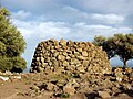
The Motorra Dolmen (Italian: Dolmen di Motorra) is a Bronze Age tomb or dolmen situated in the comune of Dorgali in the Province of Nuoro, Sardinia, Italy.
The dolmen is situated 8 kilometres (5 miles) to the north of Dorgali on the S125 road towards Orosei. A sign by the side of the road marks the track that leads to the dolmen. A few kilometres away is the Ispinigoli Cave.
The dolmen consists of an entranceway that leads to a polygonal chamber. The eight upright stones of the chamber support an almost circular slab of schist. The dolmen is one of many ancient sites around Dorgali, and is one of the best preserved dolmens in Sardinia. Finds of pottery have linked the dolmen to the Ozieri culture of the Bronze (or Chalcolithic) age, and is dated to around 2800 BC.
Text from Wikipedia, the free encyclopedia, under CC BY-SA 4.0. Full article: «Dolmen di Motorra».
Our data shows no stations, stops or car parks nearby. Check how to get there before you set out.


Dolmen di Motorra is in Dorgali, in the province of Nuoro (Sardinia), Italy. GPS coordinates: 40.30621, 9.57523.
Nearby you’ll find: Castro di Dorgali (1.9 km away), Dolmen di Monte Longu (3.8 km away), Serra Orrios (4.4 km away).
Text. Wikipedia, the free encyclopedia (CC BY-SA 4.0).
Data. Wikidata (CC0); opening hours and contacts OpenStreetMap (ODbL).
Photos. Wikimedia Commons, author and licence on every image.
Updated 28 October 2026. All sources and licences