


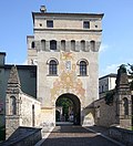


- Most beautiful villages
Photo: intoinside, CC BY 3.0 · Wikimedia Commons
Historic village
Italian comune
Cordovado (Friulian: Cordovât) is a comune (municipality) in the Regional decentralization entity of Pordenone in the Italian region of Friuli-Venezia Giulia, located about 80 kilometres (50 mi) northwest of Trieste and about 20 kilometres (12 mi) southeast of Pordenone.
Cordovado borders the following municipalities: Gruaro, Morsano al Tagliamento, Sesto al Reghena, Teglio Veneto. It is one of I Borghi più belli d'Italia ("The most beautiful villages of Italy").
Text from Wikipedia, the free encyclopedia, under CC BY-SA 4.0. Full article: «Cordovado».
Distances are as the crow flies, not walking or driving.


Cordovado is in Cordovado, in the province of Pordenone (Friuli Venezia Giulia), Italy. GPS coordinates: 45.85000, 12.88333.
Nearby you’ll find: Cecchini palace (0 m away), Sesto al Reghena (5.2 km away), Abbey of Santa Maria in Sylvis (5.2 km away).
Text. Wikipedia, the free encyclopedia (CC BY-SA 4.0).
Data. Wikidata (CC0); opening hours and contacts OpenStreetMap (ODbL).
Photos. Wikimedia Commons, author and licence on every image.
Updated 28 October 2026. All sources and licences