At a glance
Coordinates 40°16′31″ N, 8°53′00″ E About No English description yet Opening hours and directions are on this page. The full story is on Italian Wikipedia.
Read it in Italian Getting there Distances are as the crow flies, not walking or driving.
More archaeological sites in Sardinia Archaeological site Barumini (VS)
Archaeological site Pula (CA)
Archaeological site Sassari (SS)
Archaeological site Paulilatino (OR)
Archaeological site Orune (NU)
Archaeological site Carbonia (CI)
See all archaeological sites in Sardinia
Things to see in Silanus: 5 historic places
Frequently asked questions Where is Nuraghe Santa Sabina? Nuraghe Santa Sabina is in Silanus, in the province of Nuoro (Sardinia), Italy. GPS coordinates: 40.27515, 8.88335.
What else is there to see near Nuraghe Santa Sabina? Nearby you’ll find: Nuraghe Orolio (2.5 km away), Sa Perda ’e S’Altare giant's tomb (4.7 km away), Nuraghe Miuddu (4.9 km away).
Sources and licences Data. Wikidata (CC0); opening hours and contacts OpenStreetMap (ODbL).
Photos. Wikimedia Commons, author and licence on every image.
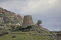
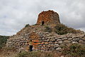
Credits for the 9 photos Silanus - Nuraghe di Santa Sabina (07) — Gianni Careddu, CC BY-SA 4.0 Complesso archeologico Santa Sabina — Antonio Figoni, CC BY-SA 4.0 Complesso di Santa Sarbana visto dal piazzale tra chiesa e cumbessias, con nuraghe in fondo a sinistra e fronte della chiesa in primo piano a destra — Tamarroverde, CC BY-SA 4.0 Complesso di Santa Sarbana visto dall'accesso all'area, con nuraghe a sinistra, chiesa al centro e cumbessias a destra in fondo — Tamarroverde, CC BY-SA 4.0 Nuraghe Santa Sabina - panoramio — paciana, CC BY 3.0 Nuraghe Santa Sabina (52469287722) — Ángel M. Felicísimo from Mérida, España, CC BY 2.0 Nuraghe santa sabina, veduta 01 — Sailko, CC BY 3.0 Nuraghe Santa Sarbana - Silanus — The original uploader was Bassbeat at Italian Wikipedia., Public domain Santa sabina e il nuraghe, veduta 01 — Sailko, CC BY 3.0 Updated 28 October 2026. All sources and licences
Spotted a mistake? Fix it on OpenStreetMap