




Photo: Mariosantoro, CC BY-SA 4.0 · Wikimedia Commons
At a glance
- Type
- Castle
- Coordinates
- 42°42′54″ N, 12°22′12″ E
History and description
Izzalini is a frazione of the comune of Todi, in the Province of Perugia, Umbria, central Italy.
The village lies along the hilly road from Todi to Montecchio, at an elevation of 417 m (1,368 ft) above sea level. It has 54 inhabitants.
History
The area was the site of Roman settlements, as evidenced by the discovery of lead pipes, terracotta jugs and coins of Etruscan origin.
The settlement was originally known as Sant'Angelo de Plebe, after its church, which was also a parish church and had jurisdiction over Collelungo. The village had a population of about 160 when, according to tradition, troops of Ezzelino III da Romano (1194–1259) seized it. After expelling the Guelphs, they fortified the settlement, transforming it into a well-defended castle, which was given the new name Izzalini.
Izzalini increased its importance with the construction in 1458 of a fortress known as Torre Baldo, to which a church dedicated to Saint Stephen was also attached. In the woods of Torre Baldo, ruins attest to the existence of a 13th-century castle said to have been built by Ilione Landone. It was therefore known as Castrum Ilionis, and later as Castiglione de Franconibus. The former settlements of San Giovanni l'Ammetato and Petacciòlo gave their names to two localities in the area.
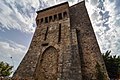
The remains of the castrum include a well-preserved tower, sections of masonry, earthworks, underground structures, and defensive bastions. Nearby, the remains of a fortified village, a parish church, and a cemetery are less well preserved. The area was completely abandoned in the 14th century for uncertain reasons, probably related to an economic and social crisis that coincided with the spread of the plague. The area around the castrum was the scene of clashes between the Lombards and the Byzantines. One of the main indications of this is provided by local toponymy, which includes place names of both Germanic and Latin origin. This has been interpreted as evidence that the territory was disputed between the Lombards and Byzantines. Castiglione was the seat of the Landi family, while the associated villa was inhabited by people subject to the local lord. The Landi also owned the nearby Villa de Franconibus, which was likewise inhabited by their dependants.
The castle of Piemozzo is comparatively well preserved. Until the 16th century it contained the Church of Sant'Andrea, which was later replaced by an oratory known as Santa Chiara.
Text from Wikipedia, the free encyclopedia, under CC BY-SA 4.0. Full article: «Castrum Ilionis».
Getting there
Todi Ponte NaiaTrain, nearest
7.3 km as the crow flies
Castrum Ilionis
Distances are as the crow flies, not walking or driving.
Loading map…
Nearby
See on the mapDo you know this place?
We are missing the opening hours. The data comes from open projects: if you add it there, it appears here at the next update.
More castles in Umbria


Frequently asked questions
Where is Castrum Ilionis?
Castrum Ilionis is in Todi, in the province of Perugia (Umbria), Italy. GPS coordinates: 42.71502, 12.37009.
What else is there to see near Castrum Ilionis?
Nearby you’ll find: Torre Caetani (7.5 km away), Palazzo dei Priori (8 km away), Palazzo del Popolo (8 km away).
Sources and licences
Text. Wikipedia, the free encyclopedia (CC BY-SA 4.0).
Data. Wikidata (CC0); opening hours and contacts OpenStreetMap (ODbL).
Photos. Wikimedia Commons, author and licence on every image.
Credits for the 1 photos
- Ruins of the Castrum Ilionis from the air — Mariosantoro, CC BY-SA 4.0
Updated 28 October 2026. All sources and licences