




- Most beautiful villages
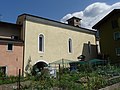
Photo: CTHOE, CC BY-SA 2.0 de · Wikimedia Commons
Bondone (Bondù, /bon'du/ in local dialect) is a comune located about 50 kilometres (31 mi) southwest of Trento in Trentino in the northern Italian region Trentino-Alto Adige/Südtirol, on the border with Lombardy. It is As of 31 December 2004, it had a population of 693 and an area of 19.2 square kilometres (7.4 mi2) divided approximately equally between the capoluogo and the frazione Baitoni which lies on the shores of Lake Idro.
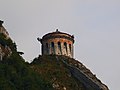
The territory of the commune rises from an elevation of 368 metres (1,207 ft) at the lakeside to a maximum of 1,946 metres (6,385 ft). The Castello di San Giovanni, offers panoramic views of the lake, and of the valley of the Chiese, with the Dolomites of Brenta visible in the distance. Bondone is one of I Borghi più belli d'Italia ("The most beautiful villages of Italy").
Text from Wikipedia, the free encyclopedia, under CC BY-SA 4.0. Full article: «Bondone».
Distances are as the crow flies, not walking or driving.


Bondone is in Bondone, in the province of Trento (Trentino-South Tyrol), Italy. GPS coordinates: 45.80649, 10.55027.
Nearby you’ll find: Castello di San Giovanni di Bondone (1.1 km away), Holy Cross church (2.6 km away), Santa Barbara Castle (3.2 km away).
Text. Wikipedia, the free encyclopedia (CC BY-SA 4.0).
Data. Wikidata (CC0); opening hours and contacts OpenStreetMap (ODbL).
Photos. Wikimedia Commons, author and licence on every image.
Updated 28 October 2026. All sources and licences