


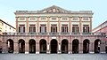


Photo: Nerijp, CC BY-SA 3.0 · Wikimedia Commons
Fortress / Tower, 19th century
Porta Santi
Gateway or arch in Cesena (FC)
Cesena (FC), Emilia-Romagna
At a glance
- Type
- Fortress / Tower
- Period
- Modern era, 19th century
- Protection
- Italian national heritage
- Coordinates
- 44°08′14″ N, 12°15′11″ E
- Address
- via Mura Porta Eugenio Valzania 2‒4 ‒ Cesena (FC)
About
No English description yet
Opening hours and directions are on this page. The full story is on Italian Wikipedia.
Read it in ItalianTimeline
- 19th centuryBuilt
Events and people from Wikidata (CC0).
Getting there
CesenaTrain, nearest
900 m as the crow flies
Porta Santivia Mura Porta Eugenio Valzania 2‒4 ‒ Cesena (FC)
Aeroporto Luigi Ridolfi15.9 km
Distances are as the crow flies, not walking or driving.
Loading map…
Nearby
See on the mapMore fortresses and towers in Emilia-Romagna


Frequently asked questions
Where is Porta Santi?
Porta Santi is in Cesena, in the province of Forlì-Cesena (Emilia-Romagna), Italy. Address: via Mura Porta Eugenio Valzania 2‒4 ‒ Cesena (FC). GPS coordinates: 44.13729, 12.25317.
How old is Porta Santi?
Wikidata dates it to the 19th century.
What else is there to see near Porta Santi?
Nearby you’ll find: Pinacoteca comunale di Cesena (400 m away), Verdi theatre (discoteque) (400 m away), Ex convento di San Biagio (400 m away).
Sources and licences
Data. Wikidata (CC0); opening hours and contacts OpenStreetMap (ODbL).
Photos. Wikimedia Commons, author and licence on every image.
Credits for the 1 photos
- Cesena-porta Santi — Nerijp, CC BY-SA 3.0
Updated 28 October 2026. All sources and licences