


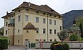

Photo: sailko, CC BY-SA 3.0 · Wikimedia Commons
Historic villa / palace
Palais Widmann
Building in Bolzano, Italy
Bolzano (BZ), Trentino-South Tyrol
At a glance
- Style
- Renaissance Revival architecture
- Architect
- Sebastian Altmann
- Protection
- Cultural heritage monument in South Tyrol
- Coordinates
- 46°29′52″ N, 11°21′28″ E
About
No English description yet
Opening hours and directions are on this page. The full story is on Italian Wikipedia.
Read it in ItalianPeople
Events and people from Wikidata (CC0).
Photos
Getting there
Bolzano - BozenTrain, nearest
200 m as the crow flies
Palais Widmann
Aeroporto di Bolzano-Dolomiti - Flughafen Bozen-Dolomiten5.0 km
Distances are as the crow flies, not walking or driving.
Loading map…
Nearby
See on the mapMore historic villas and palaces in Trentino-South Tyrol


Frequently asked questions
Where is Palais Widmann?
Palais Widmann is in Bolzano, in the province of Bolzano (Trentino-South Tyrol), Italy. GPS coordinates: 46.49786, 11.35791.
What else is there to see near Palais Widmann?
Nearby you’ll find: Domschatzkammer Bozen (300 m away), Mercantile Museum (300 m away), South Tyrol Museum of Nature (400 m away).
Sources and licences
Data. Wikidata (CC0); opening hours and contacts OpenStreetMap (ODbL).
Photos. Wikimedia Commons, author and licence on every image.
Credits for the 8 photos
- Palais Widmann in Bozen — sailko, CC BY-SA 3.0
- DSC01227 Palais Widmann Bozen 06-2023 — Aciarium, CC BY 4.0
- Palais Widmann (links), Südtiroler Landtag, Laurin-Brunnen — Vollmond11, CC BY-SA 3.0
- Palais Widmann 2019 — Plentn, CC0
- Bozen 1 (383) — User:Mattes, Public domain
- Bozen Landhausplatz Girls — Bartleby08, CC BY 4.0
- Pariser Vertrag 1946-2026 Südtiroler Landesverwaltung — Bartleby08, CC BY 4.0
- Siège Province de Bolzano — LucasD, CC BY-SA 4.0
Updated 28 October 2026. All sources and licences