





Photo: Vito di Punzio, CC BY-SA 4.0 · Wikimedia Commons
Historic villa / palace, 1930s
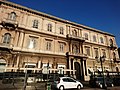
Postal Palace
Building in Taranto, Italy
Taranto (TA), Puglia (Apulia)
At a glance
- Period
- Modern era, 1930s
- Architect
- Cesare Bazzani
- Protection
- Italian national heritage
- Coordinates
- 40°28′11″ N, 17°14′20″ E
- Address
- Lungomare Vittorio Emanuele III - 74100 Taranto (TA)
About
No English description yet
Opening hours and directions are on this page. The full story is on Italian Wikipedia.
Read it in ItalianTimeline
- 1930sBuilt
People
Events and people from Wikidata (CC0).
Photos
Getting there
TarantoTrain, nearest
2.0 km as the crow flies
Postal PalaceLungomare Vittorio Emanuele III - 74100 Taranto (TA)
Amat Idrovia per Isola di San Pietro1.5 km
Aeroporto di Taranto-Grottaglie14.4 km
Distances are as the crow flies, not walking or driving.
Loading map…
Nearby
See on the mapMore historic villas and palaces in Puglia (Apulia)


Frequently asked questions
Where is Postal Palace?
Postal Palace is in Taranto, in the province of Taranto (Puglia (Apulia)), Italy. Address: Lungomare Vittorio Emanuele III - 74100 Taranto (TA). GPS coordinates: 40.46986, 17.23901.
How old is Postal Palace?
Wikidata dates it to 1930s.
What else is there to see near Postal Palace?
Nearby you’ll find: Palazzo del Governo (100 m away), Palazzo degli Uffici (300 m away), Palazzo della Banca d'Italia (400 m away).
Sources and licences
Data. Wikidata (CC0); opening hours and contacts OpenStreetMap (ODbL).
Photos. Wikimedia Commons, author and licence on every image.
Credits for the 4 photos
- Palazzo delle Poste e Telegrafi Taranto — Vito di Punzio, CC BY-SA 4.0
- Lungomare Taranto e Palazzo Poste — PhotoItaly, CC BY-SA 4.0
- Taranto, poste italiane sul lungomare 01 — Sailko, CC BY 3.0
- Taranto, poste italiane sul lungomare 02 interno — Sailko, CC BY 3.0
Updated 28 October 2026. All sources and licences