

Photo: IlirikIlirik, CC0 · Wikimedia Commons
Fortress / Tower, 1593
Palmanova Fortress
Building in Palmanova, Italy
At a glance
- Type
- Fortress / Tower
- Period
- Renaissance, 1593
- Protection
- Part of UNESCO World Heritage Site
- UNESCO World Heritage
- Venetian Works of Defence between the 16th and 17th Centuries: Stato da Terra – Western Stato da Mar
- Coordinates
- 45°54′18″ N, 13°18′37″ E
History and description
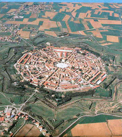
Palmanova (Friulian: Palme) is a town and comune (municipality) in the Regional decentralization entity of Udine in Friuli-Venezia Giulia, northeast Italy. The town is an example of a star fort of the late Renaissance, built by the Venetian Republic in 1593.
The fortifications were included in UNESCO's World Heritage Site list as part of Venetian Works of Defence between the 16th and 17th centuries: Stato da Terra – western Stato da Mar in 2017. Palmanova is one of I Borghi più belli d'Italia ("The most beautiful villages of Italy").
History
On 7 October 1593, the Venetian Republic founded a revolutionary new kind of settlement: Palmanova. The city’s founding date commemorated the victory of the Christian forces (supplied primarily by the Italian states and the Spanish kingdom) over the Ottoman Turks in the Battle of Lepanto in 1571, during the War of Cyprus. Also honored on 7 October was Saint Justina, chosen as the city's patron saint. Using all the latest military innovations of the 16th century, this small town was a fortress in the shape of a nine-pointed star with a 6-sided city square inside, designed by Vincenzo Scamozzi. Between the points of the star, ramparts protruded so that the points could defend each other. A moat surrounded the town, and three large, guarded gates allowed entry. The construction of the first circle, with a total circumference of 7 kilometres (4 mi), took 30 years. Marcantonio Barbaro headed a group of Venetian noblemen in charge of building the town, Marcantonio Martinego was in charge of construction, and Giulio Savorgnan acted as an adviser. The second phase of construction took place between 1658 and 1690, and the outer line of fortifications was completed between 1806 and 1813 under the Napoleonic domination. The final fortress consists of: nine ravelins, nine bastions, nine lunettes, and eighteen cavaliers.
In 1815 the city came under Austrian rule until 1866, when it was annexed to Italy together with Veneto and the western Friuli. Until 1918, it was the one of easternmost towns along the Italian-Austro Hungarian border and during the First World War the city worked as a military zone hosting even a hospital for the royal army. In 1960 Palmanova was declared a national monument. …
Ideal city of the Renaissance
Palmanova was built following the ideals of a utopia. It is a concentric city with the form of a star, with three nine-sided ring roads intersecting in the main military radiating streets. It was built at the end of the 16th century by the Venetian Republic which was, at the time, a major center of trade. It is actually considered to be a fort, or citadel, because the military architect Giulio Savorgnan designed it to be a Venetian military station on the eastern frontier as protection from the Ottoman Empire.
During the renaissance many ideas of a utopia, both as a society and as a city, surfaced. Utopia was considered to be a place where there was perfection in the whole of its society. This idea was started by Sir Thomas More, when he wrote the book Utopia. The book described the physical features of a city as well as the life of the people who lived in it. His book sparked a flame in literary circles. A great many other books of similar nature were written in short order. They all followed a major theme: equality. Everyone had the same amount of wealth, respect, and life experiences. Society had a calculated elimination of variety and a monotonous environment. The city where they lived was always geometric in shape and was surrounded by a wall. These walls provided military strength but also protected the city by preserving and passing on man’s knowledge. The knowledge, learning, and science gave form to the daily life of the people living inside the walls. The knowledge of each person was shared by the entire society, and there was no way to let any information either in or out. As Thomas More said in his book, "He that knows one knows them all, they are so alike one another." …
Main sights
The Duomo is located in front of the town hall of Palmanova (formerly the Palace of Provveditore). Commissioned in 1603, the construction started later that year under Inspector Girolamo Cappello and was completed in 1636. The identities of any architects are uncertain, but may have been Vincenzo Scamozzi and Baldassare Longhena. The Duomo was not consecrated until 1777 after the town had been included into the Archbishopric of Udine.
The bell tower of the Duomo, erected in 1776, was deliberately made short because enemies attacking the city should not be able to see the Duomo from outside the city walls.
The niches in the façade contain statues representing the saints Justina of Padua, one of Padua's patron saints, and Mark, as well as a statue of Christ, the Redeemer. The façade itself is made of stone from Istria, and was restored in 2000.
The three monumental gates Porta Udine, Porta Cividale and Porta Aquileia.
The Piazza Grande, to which all the main edifices of the city open, built in Istrian stone.
The singer Sting gave an outdoor concert in Palmanova's main piazza on 5 July 2001.
Text from Wikipedia, the free encyclopedia, under CC BY-SA 4.0. Full article: «Palmanova Fortress».
Timeline
- 1593Built
Events and people from Wikidata (CC0).
Photos
Getting there
PalmanovaTrain, nearest
1.1 km as the crow flies
Palmanova Fortress
Trieste Airport15.0 km
Distances are as the crow flies, not walking or driving.
Loading map…
Nearby
See on the mapMore fortresses and towers in Friuli Venezia Giulia


Frequently asked questions
Where is Palmanova Fortress?
Palmanova Fortress is in Palmanova, in the province of Udine (Friuli Venezia Giulia), Italy. GPS coordinates: 45.90497, 13.31026.
How old is Palmanova Fortress?
Wikidata dates it to 1593.
What else is there to see near Palmanova Fortress?
Nearby you’ll find: Palmanova (700 m away), Clauiano (3.4 km away), Strassoldo (5.1 km away).
Sources and licences
Text. Wikipedia, the free encyclopedia (CC BY-SA 4.0).
Data. Wikidata (CC0); opening hours and contacts OpenStreetMap (ODbL).
Photos. Wikimedia Commons, author and licence on every image.
Credits for the 5 photos
- Cinta muraria di Palmanova — IlirikIlirik, CC0
- Baluardi fortezza di Palmanova — Archeolucia, CC BY-SA 4.0
- Aerial image of Palmanova (view from the northwest) — Carsten Steger, CC BY-SA 4.0
- Bastioni di Palmanova 01 — Marchetto da Trieste, CC BY-SA 4.0
- Abriss der neuen Stadt und Festung Palmae — Unknown author Unknown author, Public domain
Updated 28 October 2026. All sources and licences