

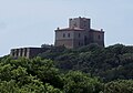


Photo: ildirettore, CC BY 3.0 · Wikimedia Commons
Fortress / Tower
Fort Rocchette
Coastal fortification in Tuscany
At a glance
- Type
- Fortress / Tower
- Protection
- Italian national heritage
- Coordinates
- 42°46′24″ N, 10°47′25″ E
- Address
- Strada vicinale della Dogana
History and description
Fort Rocchette (Italian: Forte delle Rocchette) is a historic coastal fortification located on the promontory of Rocchette between Castiglione della Pescaia and Punta Ala, in the province of Grosseto, Tuscany, central Italy.
History
The site originated as a watchtower built during the 12th century in a strategic position overlooking a small harbor that once existed nearby. A papal bull of 1188 records both a nearby parish church and the fortification, then known as Rocca de Campo Albo. By 1289 the structure was referred to as Rocchetta de Capalbi.
During the reign of Cosimo I de' Medici, the fortress was substantially enlarged and strengthened as part of the coastal defense system of the Grand Duchy of Tuscany. The reconstruction works were completed in 1568, transforming the medieval tower into a larger military stronghold.
In the late 18th century, the chapel of Madonna del Carmine was built near the fort. After the unification of Italy, the military installation was decommissioned and converted into a lighthouse. The lighthouse remained active until the first half of the 20th century, after which the property passed into private ownership.
Architecture
The fort is enclosed by polygonal defensive walls dating largely from the 16th-century Medici reconstruction. At the center of the northern side stands the original medieval square tower, which survives without its former crowning structure. Several adjoining buildings retain crenellated rooflines, while sections of the outer walls preserve their sloping defensive base.
Text from Wikipedia, the free encyclopedia, under CC BY-SA 4.0. Full article: «Fort Rocchette».
Photos
Getting there
Address
Strada vicinale della Dogana
Aeroporto di Grosseto23.2 km
Distances are as the crow flies, not walking or driving.
Loading map…
Nearby
See on the mapMore fortresses and towers in Tuscany

- UNESCO

- UNESCO


Frequently asked questions
Where is Fort Rocchette?
Fort Rocchette is in Castiglione della Pescaia, in the province of Grosseto (Tuscany), Italy. Address: Strada vicinale della Dogana. GPS coordinates: 42.77327, 10.79021.
What else is there to see near Fort Rocchette?
Nearby you’ll find: Torre di Cala Galera (800 m away), Castello di Punta Ala (5.5 km away), Torre Hidalgo (5.6 km away).
Sources and licences
Text. Wikipedia, the free encyclopedia (CC BY-SA 4.0).
Data. Wikidata (CC0); opening hours and contacts OpenStreetMap (ODbL).
Photos. Wikimedia Commons, author and licence on every image.
Credits for the 3 photos
- Le Rocchette - panoramio — ildirettore, CC BY 3.0
- Le Rocchette - panoramio (1) — ildirettore, CC BY 3.0
- Castiglione della pescaia maremma - panoramio - brunobarbato (1) — brunobarbato, CC BY 3.0
Updated 28 October 2026. All sources and licences